Chapter X.
Roads and Streets
The earliest inhabitants of Sutton naturally settled near the house of the lord, and in the eleventh century that house was the residence of the under lord (the over lord of Sutton being the king himself). This family took its name of De Sutton from the town itself, but no trace of their residence remains nor of their connection with the parish except some sepulchral slabs in the ancient Church. On the site of their home in the Tudor period a house, long inhabited by the Langfords, was built, only being finally demolished by the local authorities in 1928. In front of it was the space long known as the Top Green, but now (1932) as Devonshire Square, with the Parish Pinfold at its side. This was an enclosure in which straying cattle were impounded by an official known as the Pindar. Owners of the cattle having to redeem them by paying for any damage they had done, with a Fee to the Pindar. The last official Pindar was James Marriott. Opposite the house stood the principal Inn, the White Swan, the meeting place for many parish affairs and for all social functions such as Balls and Assemblies.
In front of this Inn ran the main thoroughfare, later known as Church Street which ran from a junction with the Alfreton Road to a junction with Forest Street, at a hollow long known as Godley's in the eighteenth and nineteenth centuries. It then passed on under a later name, that of Forest Street, crossing the town Brook at the north end of the Swine Green, with stepping stones for pedestrians ; up a hill and then on the road to the Forest, now (in an abandon of banality) named Station Road, crossed a stream called the Maun which had on it the ancient Sheep Wash. Further on it crossed, at Blackmires, the road known in a.d. 1232 as the Great Way, and leaving Hamildun Hill on the left, a mile or more later it crossed the Mansfield and Derby and the Mansfield and Nottingham roads finally joining the Mansfield and Newark road at Three Thorn Hollow near Rainworth. This road was originally a Roman track on which they carried their Lead from the mines of Matlock (Ludenorum) to the waters of Trent. A pig of Lead so marked was found at Hexgrave and is now in the British Museum with the Matlock stamp upon it.
With the sinking of a coal pit at Blackwell close to the County Boundary and then in Hucknall Breks one part of this road became much used and the coal traffic through Hucknall caused it to be known as Dirty Hucknall as early as 1546, so that in 1764 an Act of Parliament was passed the preamble of which was as follows :— "Whereas the High Roads leading from Alfreton through Carter Lane to a place in Mansfield called Stockwell, and from the Bridle Gate at the division of the Liberties of Blackwell and Hucknall through the town of Sutton-in-Ashfield to the Mansfield and Newark Turnpike at or near Python Hill in the Forest of Sherwood . . . . are through the many heavy carriages daily passing therein, in a ruinous condition and ' in some places narrow and incommodious, cannot be effectually repaired, widened and kept in repair by the ordinary Courses appointed by the Laws in being, May it therefore please your Majesty ' . . . . " Then follow the names of 316 owners of land, including some from Sutton-in-Ashfield who are appointed Trustees and empowered to appoint five to act on their behalf, and who must own land or houses of at least £40, or a personal estate of £800. They were to erect Turnpikes (or Toll Bars) and a Toll House at or near each Turnpike and to collect tolls for the repair of the roads, and to agree with the Surveyor of Sutton-in-Ashfield to keep the Sutton roads in repair for a certain sum.
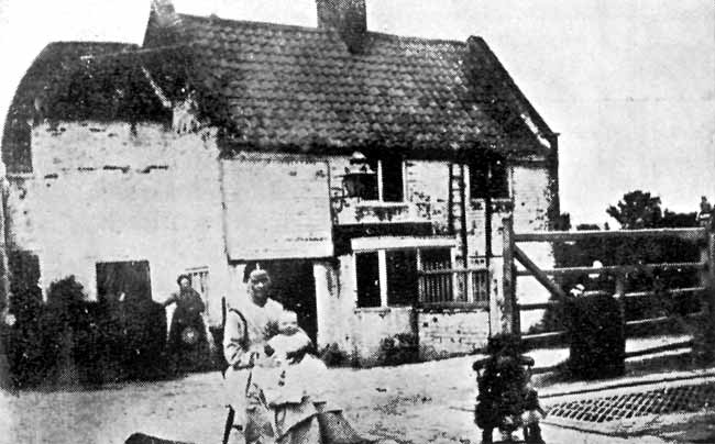
Old Toll Bar.
In pursuance of this Act Toll Bars were placed across the roads, one at the junction at Sutton Woodhouse, another at their junction with Stoneyford Lane and another on the Forest Road near to the entrance gates of the house known as Forest Lodge built in 1883 by Mr. A. H. Bonser. These Bars were finally abolished 1 July, 1872 the repair of the roads being transferred to the whole body of ratepayers through County Councils in 1894 who make grants to the local authori ties. It may be noted that Sutton-in-Ashfield was completely hemmed in by these bars, and inhabitants could not leave without having to pay a toll for their horses and carts, while by a strange anomaly the travellers from Nottingham Annesley and Kirkby could use Sutton roads in reaching Mansfield without payment of anything towards their repair. It may also be noted that the part of the Blackwell and Newark Road in the parish of Mansfield has never been made from that day to this, 1932.
The road from Alfreton entered the parish at the County Boundary crossing the hills at Fulwood (which were cut through and levelled in a.d. 1840) joined and crossed the first-named road at Woodhouse passed down Priestsic Lane by " Nue Cross," and crossed the " Great Way " passed down Forest Side, then passing on a part of the road now covered by the waters of the Reservoir and close by the Kings Mill and on to Stockwell Gate, Mansfield.
In the perambulation of Sherwood Forest in a.d. 1232 the road from Nottingham to Bolsover and Tickhill Castles was called the Great Way. It ran across Bulwell Forest, through Papplewick and Newstead Park, after which a branch passed on to Mansfield. This road entered Sutton parish at the south end of Thieves Wood, passed over Coxmoor, crossed the Maun at Blackmires and ran on to Skegby and Hegtredebrug, Estrella or Newbounds Mill Bridge.
This road lost its importance in 1764, when, on the promotion of Lord Byron, a new road was made from Larch Farm to Red Hill, and the road through Newstead Park was closed, leaving only a footpath on its ancient site. From Newstead to Blackmires at Sutton this road is for the most part derelict, and is only partly made over Coxmoor.1
The road from Sutton to Kirkby was merely a district road known as Ric, or district lane (later debased into Rice Lane) and was repairable by the bordering owners till 1795. The people of Kirkby had for many years brought their coal from Pinxton but on account of high price had transferred their custom to the Pit at Hucknall Huthwaite, and in consequence the heavy traffic soon wore this road away.
To prevent this the farmers of Kirkby placed posts across it. This led to a Petition to the Duke of Portland, and as a result a Toll Bar was placed near the village Cross effectually stopping through traffic to Sutton without paying toll.
The development of the town commenced early in the seventeenth century when many occupiers introduced Looms and Frames into their houses, and as may be seen from their Wills became fairly well to do.
John Wright in his Will 24 June, 1702 leaving 80 sheep worth £20, and Two Frames £20, Thomas Ward, 18 May, 1698, left 7 Cows, 4 Oxen, 11 young beasts, Leather in Tan Yard £140, and to his son John ' One stocking frame.'
Though the main houses were in Church Street, farms and cottages bordered the stream that ran down the centre of the village. The house now known as the Rifleman Inn in Low Street was built by the Newton family about 1610. It was the residence of John Newton who died 1661, leaving it to his wife and charging his estate with the giving of two cloth coats to the poor, a bequest still carried out today (1932).
The street from its position naturally became known as Low Street. King Street was commenced in 1661, the year after the restoration of the Monarchy, to commemorate that event. The many Puritans remaining in Sutton called it in derision Beggar Street, and in the writer's youth both names were equally common. In Club Street, taking its name from a Club existing at the Trooper Inn, stood a farmstead of the Brandreths, Spring Alley marking the site of a footpath running over Brandreth's Croft. A large spring at the bottom of the Alley emptied itself in the passing Brook. It was known as Idle Wells and was the principal feeder of that stream nearest its source. From the Green to Kings Mill Dam no houses existed north of the stream till c. 1750.
The street now known as High Pavement was called Back Lane till 1840, Reform Street marked the passing of the Reform Bill of 1832 and Union Street, that of the Union Chargeability Bill of 1847. Cursham and Station Streets were made 1855-60. The Swine Green now known as Portland Square and on which the villagers disported themselves round the maypole is degraded by a public building. Owtram Street is named from a family of that name, which, coming from Brampton, near Chesterfield, owned the land through which that street now runs. After the enclosure of the Forest in 1797 they left the town. Sutton Woodhouse stands on the Alfreton Road near its junction with the Huthwaite Road and is the site of the residence of one of the Forest keepers, John Green being the last man to hold this office in 1799. Smedley's End now known as West End owes its name to a family which had a well known Pottery at Fulwood, and who built a Wind Corn Mill that stood at the back of an Inn called the Staff of Life Inn, so named owing to its proximity.
Priestsic Lane takes its name from the small stream or Sic which crossed it at the bottom of the Priests Croft, his house standing on the Forest Street facing the Swan Inn. Carsic Dernes from the same stream across either a wet meadow on a stoney road, Willebrig, debased into Willowbridge from Wille—a spring, and Brig—a bridge, Oddicroft from an owner of that name, all these lanes having names of Anglo-Saxon origin, while the south end of Owtram Street was known as Tenter Lane from thegne a lord, it being the lane that ran down to the " lords " mill when it was set in Sutton ' Schawe '—a wood.
Nearly all other streets are comparatively modern, and owe their origin to the foundation of the business of the Unwin family in the middle of the eighteenth century; when innumerable small houses sprang up wherever a few yards of land could be found to build upon, with no local authority to control them, to provide homes for the labour that flocked into the town to work at the Sutton mills. Later the introduction of hand frames for Stocking making caused more houses to be built, many being able to be identified by the rows of windows on the upper floors.
Private enterprise provided for all demands till after the Great War with Germany 1914-18 when an Act of Parliament was passed to provide local authorities with Loans with which to build cottages. Under this Act large extensions were made at Sutton, large new suburbs springing up, and up to March, 1932 no less than 801 cottages were built, although the population had only increased from 23,852 in 1921 to 25,151 in 1931. Through the good offices of Mr. W. Burn, the following Return has been made.
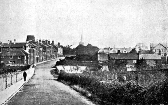
West End, Circa 1910.
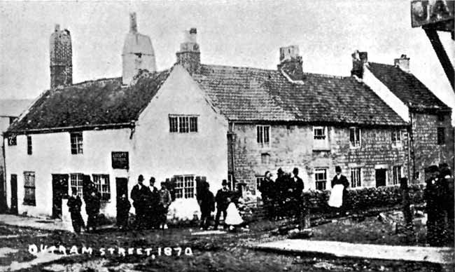
Outram St, 1870.
SUTTON-IN-ASHFIELD U.D. COUNCIL.
Housing Estates.
| Situation. | No. of Houses. | Date of Contract. |
| Hardwick Lane & Martyn Avenue | 40 | 6 April, 1921 |
| Hardwick Lane do. | 20 | 18 May, 1922 |
| do. Extension | 40 | 29 Dec. 1925 |
| Fireman's Row, Church Street | 8 | 30 Sept. 1926 |
| Spring Road, Beeley, Garside and | ||
| Stevenson Crescents | 120 | 29 Sept. 1926 |
| Garden Lane, Hibbert and Tuds- | ||
| bury Terraces | 100 | 10 May, 1927 |
| Alfreton Road, Frederick Street | 64 | 3 April, 1928 |
| Spring Road, Luther Avenue | 56 | 12 June, 1928 |
| Eastfield Side, Brown Crescent | 50 | 15 May, 1929 |
| Sherwood Road, Collins Avenue | 50 | 20 Dec. 1929 |
| do. Extension | 42 | 12 May, 1930 |
| Eastfield Side, do. | 26 | 26 Nov., 1930 |
| Willowbridge Lane, Bonser Gar- | ||
| dens | 50 | 10 Feb., 1931 |
| Station Road, Forest Road | 76 | 20 July, 1931 |
| Twitchel, Footway to Kirkby | 59 | 7 Sept., 1931 |
| Private Owners and Builders, Mr. A. Farnsworth and others | ||
| from 1918 to 1932. | 612 | |
| In 1905 the Market Place was enlarged, the whole of the pro- | |
| perty on its north-west side being removed, after purchase | |
| from the Home Brewery for the Market Hotel | 1,950 0 0 |
| Tophams | 2,150 0 0 |
| Saml. Unwin's Representatives | 5,000 0 0 |
| H. Challons do. | 1,050 0 0 |
| Congregational Chapel, King Street | 2,000 0 0 |
| F. Vallance & Westwick | 1,082 0 0 |
| Dove's Trustees, Houses and Land | 1,100 0 0 |
The Clause following was mutually agreed upon :— "The purchasers shall pay the existing Tenants of the said premises the value of their fixtures (if any) at the expiration of their respective tenancies. And in the event of their acquiring the property adjoining the said premises shall give to each of such existing tenants, the option of purcha ing one site," etc.
1 This ancient road was ordered to be re-conditioned by the U.D. Council in 1939.