Map-tracing of Roads through Nottingham, South to North.
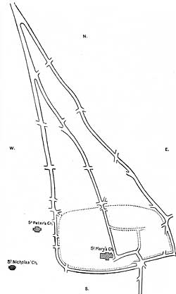
Map III.
Tracing No. III. shows the remarkable road system through the medieval town, expanded into three lines north of the old enclosed hill site, and restricted to one only in the low-water meadow in the south. This latter line is here shown as the present Bridge-street, but the great stone bridge of history stood immediately along its western side, and was not in a line with the foot of Hollow-stone. The area of the "old burh" is marked by dotted lines, with the original "Stan-street "passing through it, and the winding of the road rendered imperative by climbing the cliff to the enclosed hill-site. In the later coaching days this winding portion, with great improvements in width and gradients, became a toilsome part of the London to Leeds mail-line, passing to the south of St. Mary's church and joining the westernmost of the three northern roads here shown. Another line, turning westward at the bridge and skirting the old burh below the precipice gained the western road by what is now the most picturesque part of the city, Drewry Hill and Bridlesmith Gate. Long before the 13th century walling-in of the joint towns this western line was established as the great through north road of the eastern half of this island. Of the three roads the eastern low-level was the most practicable. When wheeled vehicles came on the scene, as indicated by its name of Millstone Lane registered in Dr. Thoroton's map, 1677, its variant "Sandy Lane," which still lingers, applied mostly to its northern part on the hill of the gallows. On its eastern side lay open commonable town land: the strip of land on its western side was early enclosed in severalty and has a history of a lost chapel and cemetery of St. Michael, the hospital and chapel of St. John, St. Leonard's Hospital and Cross, alias the High-Cross in the fields or Spital-Cross of the 14th century. Under all this is supposed to be the lost hamlet of Wiston (Hwyston) of which we heard an echo in A.D. 1217. (Records, Nottingham, vol. I., 441.) (Page 61 above.)
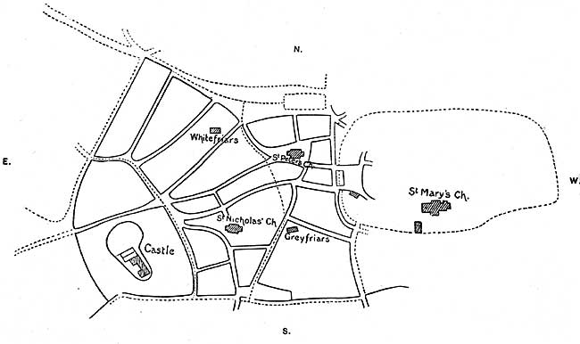
Map IV.
Map-tracing of Nottingham, New Borough.
Tracing No. IV. shows "The land of the Earl," and its relation to the old Burh, with the appearance of having been carved out of the old town's surroundings to make a separate holding. It has no natural boundaries, but land of the old town on four of its five sides. Along the south is the water-line of the river Leen, an artificial work of unknown date wrought to convey water from Lenton to a grist-mill of the old borough, erected due south of St. Mary's church, the record of which still lingers in the low part of the old town as "Maltmill-lane." This water-course was later tapped on its south bank for one or more mills associated with the Earl's land, or the Norman Castle: further south, where now runs the canal, was a natural drain (Tinker's Leen), which was wholly in St. Mary's parish; this formed the north boundary of the open or burgess land of the Meadows; the narrow strip that parted the two courses was known as "Between the waters," and has an interesting history, this "land of the Earl" area, is here divided into three sections by dotted lines; the west one—that of the Norman Castle—came down to us as "extra parochial," the central one as St. Nicholas parish, and the east one as St. Peter's, I here indicate the chapels or sites of the two medieval friaries; that lying N.W. was the Whitefriars, that S.E. the Greyfriars. They had each a difficulty in getting into the town, or breaking through the opposition of the priors of Lenton—the spiritual lords,— and they succeeded only in the so-called "New borough" that had no "great" or "corn-tithe." They preached the doctrine of poverty, a plague of the flesh to the old priors, but in practice the new ones were quick to become the owners of the great areas in which their houses were corners. That of the Greyfriars fell short at the S.W. corner of their land, where "Albion Street" is figured on the map (see further Badder & Peet's map of 1744). I read this late Corporation property to have been the site of the historic dyeing business createda monopoly by royal charter, Hen. II. (1155-1165). "Nor ought anyone within a radius of ten leucae of Nottingham to work dyed cloths, except in the borough of Nottingham," the record of which is our present "Lister Gate," from a forgotten "Lyts-ter," or old Norse verb "lita" to dye, this rare example of old street nomenclature appears to be partly submerged under the later "Grey Friar's Gate." If this leucae is translatable by "league"—an old measure implying three miles, in all thirty miles, it would exclude Derby, and Newark, but not Mansfield, a King's chief manor, where "Lister Gate" (now Church Lane) lingered as a dyer's business quarter in the town to the last half of the last century.
This tracing further shows the share of this Earl's town, in the Great Market, with the Market-wall dividing it, running from east to west.
Turning by way of contrast to the "Old Burh," I give what I take to have been the area of that "mid-week," or "week-day," or "Wednesday"—market area, before the Saxon "fleshers," or "flesh-hewers" booths became fixtures—which could pass with their sites into private hands. This seems to account for "Byard lane," (the "Woller lane" of Speed's time, the earlier "Walleone lane" of A.D. 1315.—Records, Nottm., vol. I., p. 440), being out of line with "Pepper Street" and "Pilcher Gate" (for its later contracted market space see the map, 1832). As a feature of this old market (which possibly dates from the town being selected as the metropolis of the county, say in the 10th century), I also mark the site, now abandoned, of the "Moot," or "Guildhall," and prison of the royal manor or borough, in contrast with the larger and more important Shire Hall and sheriff's prison of the county, on the tall cliff by the S.W. corner of the great church of St. Mary, which was studiously reserved from incorporation in the municipal borough by Henry VI. charter, of June 28th, 1448.1 (Page 65 above.)
(1) The Moot-hall of the New Borough became Whitefriars.