Blyth
By William Stevenson
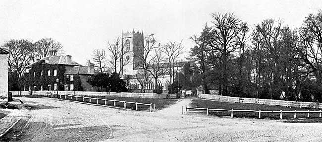
BLYTH CHURCH; SOUTH-EAST VIEW FROM THE ROAD.
I HAVE the honour to address you upon the subject of this ancient town, and its great religious foundation. Centuries ago it was one of the largest towns in the county, endowed with great and flourishing foundations, fairs, and markets. The situation on the great northern highways, one, via Rufford Abbey, passing through Nottingham, another, via Barnby-moor, through Newark, rendered it important. It is about 50 miles from York and 150 miles from London, and there were few of our mediaeval kings who failed to visit it on more than one occasion. The same may be said of the archbishops, bishops, abbots, and priors of the north part of the kingdom, with their processional crosses and their great retinues, wending their way to and from London and the Continent. Of its Anglo-Saxon lords nothing is known. It appears to have consisted of three holdings, one of which was attached in its government to the manor of Hodsock, one to the king's great manor of Mansfield, and another to the royal manor of Bothamsall.
The name implies an important crossing of the river, upon which it stands, and that it was early called Blythford, or Blyth-bridge, on all fours with Cambridge on the Cam.
"Blyth" is a river name, and it appears that the old town dropped or lost its suffix of ford, or bridge, and became known by the old river name only, as in the instance of Blyth on the Blyth, in Northumberland. A new name was found for the river, one borrowed from a neighbouring Tillage higher up the stream, and it became, as it is to-day, the river "Ryton," which is not a proper river name. A parallel case is found in the great river of Lincolnshire. It lost its original name of "Grant," or "Granta," which is preserved in Grantham, and took up the name of a village on its course, and thus became the river Witham, which means "a town at the crossing of a river," and is not the proper name of a river.
The greatness of Blyth commenced soon after the Norman Conquest, and was due to a Norman baron, Roger de Buille, one of the favoured nobles of the Conqueror, becoming its lord. He was endowed with nearly the whole of north Nottinghamshire, and a considerable part of Derbyshire, "to have and to hold by his sword." He chose for his home an important earthwork four miles N.W. of this town, which was improved into a Norman castle, the centre of the great honour of Blyth and Tickhill. Like other Norman barons he came to view his sword as the emblem of the cross, and to mark his devotion to Holy Church he founded a monastic institution. In doing this he selected Blyth as the site of a priory, and hence the origin of this ancient church.
There was unquestionably a manor, village or parish church here long before the foundation of this priory, which embraced the three divisions of land above noted, all known by the name of Blyth, in the great survey of 1086. Two years after this survey, viz., in 1088, that is 813 years ago, this priory was founded, and the founder, who twenty years before had fought at the Battle of Hastings, endowed it with the church of Blyth and other of his lands and churches. In due time the monastic buildings were commenced—the habitation of the prior and his brethren, and again in due time the erection of their great church, of which this is the western limb, was taken in hand. The architectural character of the building is not so early as the foundation of the priory. I take it to be about a quarter of a century later, viz., from 1110 to 1120. During this period the monks would possibly have a temporary chapel in some part of their domestic buildings.
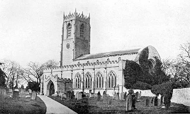
Blyth church from the south east.
Turning to the village church, of which the prior was the rector, it appears to me to have stood on the mound in the centre of the village, beside which is situate the present vicarage house. This site has long been consecrated ground, and is thick with interments, regarding which history is silent.
In the Edwardian period, or about two and a half centuries after the foundation of the priory, the prior and convent appear to have decided to absorb the village church in their monastic church. With this view the south wall of the south aisle of the nave was taken down and rebuilt about double the original width of the aisle, and it became the parish church. The tower of the original church, erected at the intersection of the nave and transepts, remained monastic.
To overcome the difficulty of absorbing the parish church, a second bell tower was erected towards the west, and the custom of standing it in the church itself was adopted, by which an entire bay of the nave was absorbed. This being done a considerable portion of the monastic nave and north aisle was thrown into the parish church, and the monastic church was contracted to the choir, transepts, and the eastern bays of the nave and north aisle, all of which were destroyed at the Dissolution ; the parish church portion alone remaining.
On the transference of the parish church to the interior of the monastic church, it appears to me that the old church on the mound in the village was destroyed, and the present oriented building, known as the parish school, but possibly originally a chapel, was erected.
The late Rev. Jno. Raine, M.A., vicar of this church, in his able History of Blyth, 1860, suggested that this site had been occupied by a hospital of S. John the Baptist; but as the interments in stone coffins reach back to such early times I look upon it as the original cemetery of the township. Being an artificial mound of considerable size by the side of a Roman highway, the question may be asked, was it not a place of pagan interments retained for the same purpose in Christian times?