< Previous | Contents | Next >
4. Surface and General Features.
Our county lies in the southern portion of the large plain whose drainage falls into the Humber. This portion is called the Vale of Nottingham. It is bounded on the west by the Pennines, and on the east and south by the Lincoln Cliff and its natural continuation the Belvoir Escarpment. These boundaries all lie outside the county but nevertheless have greatly influenced its history and commerce. At the south-west corner there is a gap of low country towards which the valleys of the Erewash, Derwent, Upper Trent, and Soar converge. This gap is the natural gateway from western and southern England into Nottinghamshire and thence to the north.
Three minor gaps leading from Lincolnshire and the south occur at Lincoln, Ancaster, and Grantham.
The county is largely lowland in character. Only one fifty-sixth of its area is above the 6oo-feet contour, and no less than two-fifths is below 100 feet in altitude. Generally, as we have seen, the lower ground is in the north and the east; the higher in the south-west. The latter is formed partly by a continuous range of hills which flanks the Pennines, but is separated from them by the valleys of the Erewash and Rother. These hills slope steeply westwards and gently eastwards. The highest ground in the county is situated in the district round the Robin Hood’s Hills, just where this range is joined by the watershed between those two rivers. It culminates near Hucknall-under-Huthwaite in a height of 651 feet. North of this the range lies outside the county, southward it passes as a gradually declining spur which disappears west of Nottingham. This range will be afterwards referred to as the Western Hills.
The highest ground south of the Trent is formed by a northerly spur of the Belvoir Escarpment. This is known as the Wolds and dominates this corner of the county.
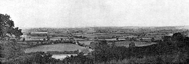
Vale of Belvoir from Green Hill near Wartnaby (Plain formed by Lower Lias Clays and Limestones).
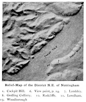
A broken range of hills commences in the eastern suburbs of Nottingham, and sweeps northwards along the central axis of the county, ending abruptly at Gringley-on-the-Hill. Its course thus lies parallel to and 15 miles from the Belvoir Escarpment and the Lincoln Cliff. The detached portions of these central hills decrease in height from 580 feet at Cockpit Hill to 253 feet at Gringley. From their summits the ground falls rapidly to the west and very gently towards the east. The western outlook from Cockpit Hill is occupied mainly by the Western Hills, that from Gringley by an extensive area of low country, the Vale of the Idle. The eastern outlook is, everywhere, over a plateau which slopes gradually until it is lost at the fringe of the county in the Vale of Belvoir and the plain of the Trent.
Between Nottingham and Newark the continuity of the plateau is broken by the Trent Vale, which here cuts across it like a great trench two miles wide. The hills which bound the vale on the south-east are called the Trent Hills. The surface of the plateau is everywhere beautifully diversified with little “dumbles” and valleys which open on to the vale. The whole presents a fair example of a miniature dissected plateau.
North of Gringley lie the flat Carr lands or fenlands. These, together with portions of the valleys of the Idle and the Trent, were at one time swamps. Though this country is now well drained and cultivated, the memory of its former condition is still perpetuated in such names as Mattersey (ey = an island), and Misterton Soss (Sass a dirty puddle).
Up to the close of the sixteenth century the Royal Forest of Sherwood had an area of about 100,000 acres. At that time its borders extended from Nottingham up the Leen to Newstead, thence through Kirkby and Skegby to the Meden and along that stream to Perlethorpe ; from this place it stretched southwards along the North Road, Dover Beck, and the Trent back to Nottingham. It consisted of open wastes and woodland and was a favourite hunting-ground of the early kings.
In later times the timber from its oaks was in great demand and was used, among other purposes, for the Navy and in the construction of St Paul’s Cathedral. Many of the great parks in the county are enclosed portions of this ancient forest.