< Previous | Contents | Next >
Chapter II.
Colston Bassett in 1600
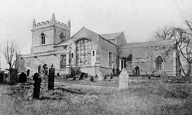
The church about 1880.
THE proof, that there was no village around the old church in the year 1604, is contained in a map. This map itself is not an old one, but it was copied, probably about 80 years ago, from one of much older date. It is described, in the handwriting of Rev. Joshua Brooke (the second vicar of that name) as “Copy of a Map of Colston Bassett in the reign of Queen Elizabeth.” As we shall see presently, it is almost certain that the original map must have been made in the year 1600. The village is shown where it now is; there is no trace whatever of any village, or of any buildings at all, near the Church.
Whenever this map was made it appears that the enclosure of the greater part of the common fields, stated by Thoroton to have been made by the second Edward Golding, had already taken place the boundaries and names of the separated closes being given. Erections of a public nature are marked such as the church and the market cross. Other buildings are marked by little pictures of houses about 50 in all most of these standing in their own strips of land; in almost every case the name of the occupier or owner is given; 35 different personal names occur a few of them more than once. Here is a list of them in alphabetical order; it gives the names of the chief inhabitants of the parish at the time the map was made: I have added within brackets, a few particulars taken from other sources such as the parish registers and bits of wills preserved in the Probate Registry at York.
Tho. Affins (Thomas Fynnes the elder husbandman buried 30 Oct., 1610).
Jo. Barrow. (A daughter of John Barrow died in the plague year)
Tho. Beck.
W. Bingham. (William Bingham, husbandman, buried 6 July, 1609).
W. Blage. (William Blagg the elder; husbandman, who was buried 10 April, 1621).
Tho. Burden (buried 2 Sept., 1604)
T. Cawnte.
W. Cawnte.
Tho. Clerk (buried 18 Aug 1604)
Mat. Harte (perhaps this family moved to Kinoulton, where the name Matthew Hart occurs frequently for several generations).
W. Harwell, gen. (This name occurs three times on the map: several times in the registers, baptisms of his children; and twice on the bells. The 4th bell, cast in 1600, bears the names Edwardus Golding and Willielmus Hairwell; while the tenor bell bears the name of William Harewell Gent. He appears to have been a son-in-law of the first Edward Golding and probably came from Suffolk.)
Barthol. Benson (husbandman, buried 6 Oct., 1604. He, his wife and two children were buried within a month, all victims of the plague).
Tho. Henson (labourer, buried 18 Sept., 1610).
R. Hoe (probably Robert Hoe, who died in 1618).
Roger Holmes (labourer, buried 8 Jan., 1600).
Tho. Huckerby (blacksmith, buried 27 Dec., 1622. His son, Matthew Huckerby, weaver, died in 1616).
Mr. Hutchinson libe. (No doubt the squire of Owthorpe. The abbreviation “libe.” denotes that the tenement bearing his name was his freehold.)
T. Lytherland (husbandman, buried 6 June, 1619. He was probably grandfather of Rev. Roger Litherland, afterward vicar of the parish.)
Tho. Marshall (buried 13 June, 1610).
Nicholas Needham. (This name is written, on the map, beyond the Kinoulton boundary. He was buried there in 1615.)
Jo. Parker. (John Parker, the elder, husbandman, died in 1626).
W. Parker. (William Parker the elder, husbandman, buried 23 Sept., 1616.)
Hen. Parnham. (The surname occurs in the registers a few years later, but there is no mention of a Henry. Parnham has been a common name in the district for at least 400 years, especially at Sutton and Granby.). Edm. Pyke.
W. Pyle, Jun. (Probably another Pyke. William Pike the elder was buried 2 Nov. 1604. Another William Pyke the elder, husbandman was buried 13 June, 1610; he would have been “the younger” until 1604.)
Jeffery Robinson (buried 2 Sept., 1604).
J. Robinson (two tenements so marked; perhaps Jeffey again, but there was also a John.)
Laur. Robinson (two tenements. The name Laurence Robinson occurs frequently in the Langar registers, and also at Hickling.)
Hen. Saxon (died in 1620.)
Tho. Sherwood (buried 26 May, 1602).
Will. Sherwood (buried 22 Sept., 1604.)
M. Smythe (probably Margery Smith, widow, who was buried 17 Oct., 1604).
Robt. Thirkell (died 1630.)
Ro. Walker (perhaps Robert Walker, who died in 1641).
M. Wright (two tenements. Margery Wright, widow, was buried 7 Dec., 1602.)
The dates of burial given above are important in helping to fix the date of the map. Of the different persons named on the map we have six who died in 1604, victims of the plague; two died in 1602, and one in 1600 (reckoning that year as ending on March 24th, and not on Dec. 31st). If I am right in every case in identifying the person named on the map with the one in the burial register, then the map must have been made before the end of the year 1600.
This date is practically confirmed by the map itself. There is on the map a tenement marked Dna. Reg., and two others marked D.R. (one of which also bears the name of J. Robinson). These are abbreviations of “Domina Regina” this means in English Lady Queen or Her Majesty the Queen There can be no doubt that these are the three tenements referred to in the Letters Patent of Queen Elizabeth whereby she granted to Anthony Nevell the former possessions in Colston Bassett, of the Priory of Launde, which had remained in the hands of the Crown since the Dissolution of Monasteries in Henry VIII’s reign; these tenements are described as being formerly in the tenure of the relict of John Harte, Jeffrey Robinson and William Welles respectively. The date of the grant is 27 March, 1601.
Looking in the other direction, here is a list of some of the inhabitants who had recently died. In 1598, Robert North, labourer; Thomas Porter, Alice Porter, widow; William Orson, carpenter: John Wells, husbandman. In 1599, Robert Clarke, husbandman; Gualter Marshall, labourer. In 1600 Edward Caunt, husbandman. it is certain that most of these would have been on the map, if they had been alive; yet, by the time the map was made, the families of Clark, Marshall and Caunt seem to have descended a generation. One feels tempted to date the map between the burial of Edward Caunt, 10 Aug. 1600, and the burial of Roger Holmes on 8 Jan. following.
It is clear from the registers that there were some other families in the place, whose names do not appear on the map. Probably they were the actual farm-labourers, living in hovels attached to the different farms, and their condition must have been wretched in the extreme. A few names, it is true, appear on the map of those who are described as labourers; but as their tenements included a certain amount of land, we should probably describe them now rather as cottagers.
We have now exhausted the map so far as personal names are concerned. The families, which these names represent, have all of them vanished from the parish many years ago; though it is possible that there may be descendants of some of them through their daughters. In the list given above there is one name which is found in the place now, that of Henry Parnham; but in between these two there has been a gap of about 200 years without a Parnham.
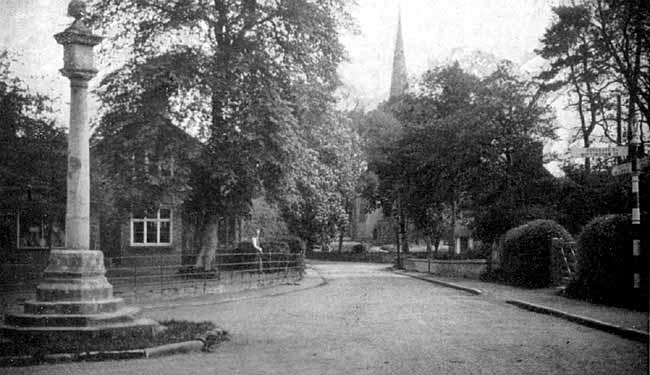
The market cross, Colston Bassett.
We will now turn our attention to sundry erections of a public nature, including some houses which may be described as official residences. It would be as well to take these in order of their position, and we cannot have a better starting-point than:—
THE MARKET CROSS. This is marked in exactly the same position as it now occupies. On 3rd Sept 1257, King Henry III made a grant to Ralph Basset, of Drayton, the younger, and his heirs of a weekly market on Wednesday at his manor of Colston Basset and of a yearly fair then on the vigil, the feast and the morrow of St. Faith. On 6 April, 1284, at the request of Ralph Basset his son, King King Edward I made a grant to him and his heirs of a weekly market on Friday instead of Wednesday, and of the yearly fair as before. Probably the weekly market and the three days’ fair from the 5th to the 7th of October were sources of considerable profit to the Basset family besides being of advantage to the people of the neighbourhood. Both have vanished, but possibly some part of the original cross may remain; it was rebuilt in 1831 to mark the Coronation of King William IV.
BEADHOUSE. About a hundred yards up the lane which now leads to the school, on the right-hand side, was a piece of land with a house marked “M. Wright pictat”; and in a corner of this is what appears to be a small building, with the word “bead.” This points to the existence of an almshouse, or some such charitable institution, possibly supported by the rent of this piece of land and also by that of two closes elsewhere which still had the names of “Beadhouse Close” and “Lower Beadhouse Close” as late as 1842; these two closes are now included within the hall grounds. All traces of this almshouse and its endowment have vanished.
THE CHAPEL OF ST. IVO. This is marked on the map between the bridge and the present post-office. There is a somewhat hazy tradition of there having been a church near this spot, the foundations of which church are said to exist still. Ralph, the last Lord Basset in his will made in 1389 made provision for four chantries to be founded to pray for his soul far ever, one of them to be “in the new Chapel built by me at Colston Basset, in honour of St. Ivo, for which I gave £200.”
The chapel was probably built in 1382; certainly its endowment dates from that year. For, on 15 Dec., 1382 there was held at Nottingham what was known as an “inquisitio ad quod dampnum”; this was an enquiry, made by an officer of the Crown by the oath of twelve good and true men, to find whether it be to the damage or prejudice of the King, if leave be granted “to Ralph Basset, of Drayton, knight, that he give and assign to a chaplain celebrating for the souls of the said Ralph, of his father and mother and ancestors and of all the faithful departed in the chapel of St. Ivo of Colston Basset daily according to the ordinance of the said Ralph.” The result of this enquiry was that permission was given to the said Ralph Basset to assign to the chaplain and his successors a messuage and three virgates of arable land and 8 acres of meadow, the worth of these being 4 pounds; it being found that the said Ralph would still have lands and tenements remaining to him in Colston Basset, which are held from the King, sufficient for all due services and customs.
No doubt the endowment of the chapel was confiscated at the time of the Reformation, as were all such endowments as had been given for what then came to be looked upon as superstitious uses. If the building itself still remained, as the map seems to show, it would not be used for religious purposes; it is; probable that it was pulled down during the times of the Civil War, when much destruction befell ecclesiastical buildings.
CROSS. Following the Hall Lane, then known as “Nottingham Waye,” for about 100 yards, we should reach another Cross standing by the road-side. Of this no trace or memory survives ; its fate would be similar to that of the chapel.
At this point a road went across to the right; just below the present Hall gardens along this road were two houses, occupied by Robert Hoe and Thomas Litherland. A little way further, at the top of the hill, a short road-way went off to the left; now marked by the remains of the avenue. There were houses on either side of this road, five in all. Three of these were occupied by Thomas Affins, William Bingham and Robert Walker. Of the others one is marked:—“WEAVERS.” In those days there were weavers to be found in every village and here we have one building specially used for making up the wool, locally obtained, into rough material, for local use in clothing the inhabitants. The villages of England were then far more self-supporting than in these days of centralization.
The remaining house in this small group was:—
THE VICARAGE. This appears to have outlasted the others, and survived until the bulding of the present vicarage about the year 1834 when the younger Joshua Brooke became vicar. It may be mentioned that the vicar’s glebe is now practically the same as it was in 1600. The site of the old vicarage is now marked by the first of the youngest trees on the right-hand side of the avenue. On the other side of “Nottingham Waye” are two groups of buildings of importance, but not marked with any personal names. The first of these includes the:—
MANOR HOUSE. This group is marked as “Scit. maner.,” the site of the manor, and consists of five or six different buildings. It would seem that all these buildings stood somewhat nearer to the river than the position of the present hall. What they all were it is difficult to say. The one in the centre of the group is certainly the manor-house; apart from the church it is the largest building on the map, apparently the only house with two storeys, with the additional distinction of a porch. A building adjoining the road was perhaps the great barn; there might possibly be a brewhouse, or a dovecote; whilst one small picture looks as if it might be intended to represent a wind-mill ; if not, then there is no mill of any kind on the map. A wind-mill is mentioned as belonging to the manor in 1580. In 1572 the manor-house was in the occupation of Thomas Hutchinson the elder; at the date of the map it is probable that it was still occupied by a member of this family.
THE RECTORY. This is the name given to the second group of buildings, in this case four in number. These are marked in a square piece of land of about two acres, the centre of which would be close to where the garage of the hall now stands.: The largest of these buildings was, no doubt, the residence of the farmer of the rectory property, formerly part of the possessions of Laund Priory, but at the date of the map the property of the Queen. Reference to this has already been made, and other reference will be made further on.
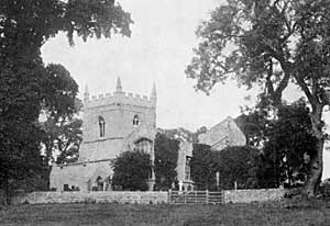
The church about 1920.
The only other building to be noticed here is THE CHURCH. This, of course, is marked in the position still occupied by its remains. A full description of the church, in its ruined condition, is given in Mr. J. T. Godfrey’s “Churches of the Hundred of Bingham.” This was written in 1906; since then four monumental slabs, formerly part of the floor of the church, have been disemcumbered of rubbish, thoroughly cleaned and set up against the south wall of the church outside; whilst one of the pinnacles of the tower was blown off in a gale in 1925. The church was chiefly built of local stone; tradition speaks of “Stone Pit Close” as being the place from which the stone was dug, and it is quite likely that “Sand Pit Close” contributed a share towards the building.
THE GALLOWS. This is the last erection, we cannot call it building, left to be noticed. On the northern border of the parish and touching on the right bank of the Smite is a close marked on the map as Gallowshill; it still bears that name. In the map this close is ornamented with a little drawing of a gibbet. There still seems to be some slight trace of the mound on which it stood. Its origin may perhaps be found in the; privilege, sometimes held by the lord of a manor in mediaeval days, of sentencing culprits to capital punishment. There are many more names on the map besides those which have been mentioned. Besides the different tenements, already described, which formed the actual village, we have the remainder of the parish divided into about 170 closes, or fields as we should now call them, nearly all of these marked with their own names. The origins of these different names must be very various. In the case of some that have been already mentioned, the origin is fairly obvious, such as Gallows Hill, Stone Pit Close, Beadhouse Furlong.
Some are named from their situation; such as Chyrchmoore, Tythbye Gate, Nottingham Gate Furlong, Long under Owthorpe, Langar Close and Langar Gate, Townend Gate, Long under Colsey. The name Mill Hill occurs in two places; but, as no actual mills are marked, it is probable that these closes are named from mills which had formerly stood there.
Others seem to be named by the nature of the soil; such may be Over and Nether Sandlands, Stony Lands, Stony Wong, Long Marsh, Sandy Barrowes, Wet Furrowes.
A few names seem to refer to what was grown on some of the closes; either by cultivation, as Peasland and Flaxmoor; or by nature, as Thistle Hill, Whinlands and Bushy Close. The last named close occurs on a part of the map which is now in Kinoulton parish.
Yet again there are several closes bearing personal names, probably from the occupiers or owners. Thus we have Taylor’s Close, Stanly’s Lee, Treoman’s Close. Aldham Bank may have been named after the wife of the first, Edward Golding; her name was Mirable Aldham; the name Aldham’s Close still survived in 1842. In this class may be included such names as Stewards Lees and The Parson’s Acres.
Here are a few names which look as if they might have an interesting origin, but in most cases they are beyond the writer’s knowledge and even beyond his imagination:— Bretlands, Holbrink, Rowshawe, Cawdwoll (or perhaps Cawdwell) Hill, Allomsyke, Mary Wong, Swabbes, Strome (now Stroom), Dunstow, Wrong-lands, Prymarowsa, Rapple-toft, Marstall, Swanborowes, Beesholm and Chamaderna Wet Furlong.
The following names call for more special notice.
STREET WAYE. This name is given to the road leading from the Harby road towards Hose. The name indicates that this was part of a Roman road, and also that it was a paved road it is well known that the Fosse Way, one of the great Roman roads stretching right across the country, was a paved road, and that it remained so, until comparatively recent years, in that part of it nearest this parish. As regards our Street Waye, some of the original paving stones were removed only a very few years since. The direction suggests that this was part of a road leading to the Roman town or camp of Margidunum, traces of which may be seen by the side of the Posse Way beyond Bingham. Another proof of the antiquity of this road is that it forms, for sonic distance, the boundary between the counties of Nottingham and Leicester.
HINGHOE or THINGHOE FURLONG is the name given to a close lying next to Gallows Hill. The “Thing” was the national or tribal council of the Northmen to this day the Norwegian Parliament is called the Stor-thing, which means the Great Council. Thing-hoe means the Council Hill1; it is suggested that this was the meeting-place of some council of importance during the times of the Danish occupation, a district council or even a county council of bygone days. But perhaps, after all, we cannot claim to possess a Council Hill in our own right. It is possible that the Goldings may have imported the name with them from Suffolk, when they were giving names to the newly-formed closes. Hengrave, the Suffolk seat of Sir Thomas Kitson, is in the Hundred of Thingo. So we must not press our claim too much, unless we can find earlier references to this name in Colston.
KNIGHT’s WONG. The Bassetts held Colston Bassett directly from the king by the service of one Knight’s fee; instead of paying rent, the owner was required, in time of war, to send a knight, with a full retinue of squires and men-at-arms and all their necessary equipment, to serve in the king’s army. These again would receive no cash payment for their military services, but would hold land from the Lord of the Manor, otherwise rent-free, This may well account for the name of the close called Knight’s Wong.
BRIGGLEES. The close so named was near the place where the bridge, known as China Bridge, now stands. It is possible that there was a brigg or bridge at this place in 1600, or, seeing that no such bridge is marked on the map, that there had been one there at some previous time.
It must be noted that many of the names of the different closes have now vanished. Some are now known by other names; and in many cases closes have been sub-divided, thus bringing the need, in each case, of at least one new name. On the other hand many of the old names survived. A fairly complete list of the closes, owned by the Golding family in 1680, can be drawn up from the depositions in a suit respecting the vicar’s tithes; the approximate acreage of each is given. But, the only other list available is contained in the tithe Award of 1842. It may be noted that in 1600 the parish was divided into about 230 tenements and closes; the Tithe Award gives particulars of 355 holdings.
COLSTON and COLSEY. This seems to be an appropriate place for a few remarks on the name of the village itself. For these we are indebted to Dr. Heinrich Mutschmann, in his book, “The Place-Names of Nottinghamshire.” “Ton” is one of the most frequent endings of English place-names; “ton” or “tun” was originally the paling or hedge with which the Teuton settler surrounded his homestead; it was afterwards applied to the whole enclosure, the homestead or farm. “Col” is a personal name; it is either old English or more likely of Scandinavian origin. The name is also found in other place-names in the county, viz.: Car-Colston, Colwick and Collingham. We might, weave a little romance and suggest that Col was a great Danish leader and gave his name to all these places; that he himself made this Colston his headquarters; and that Thing-hoe became the meeting-place of the council of the whole district of which he was the recognized chief.
The same writer suggests a derivation for the name Bassett, Further north in the county is the hundred of Bassettlaw, which he derives from old English words meaning “the law, or mound, of the forest dwellers.” He adds, “Soon after the Conquest a noble family of the name of Basset is found in this hundred; they evidently take their name from the property owned by them in the division.”
In the same book is mentioned an old English word “smita,” meaning “a foul, miry place” so that the river Smite seems to mean “the dirty, miry stream.” Surely this must have been prophetic of the mud for which Colston Bassett is said to be famous!
The name Colsey is closely connected with Colston and means “Col’s Island.” The name appears on the map as Colsey Hill, where now is the farm-house known as Colston Hill Farm. It is not difficult to imagine the site as comparatively dry ground, rising slightly above the level of surrounding marshes and therefore aptly described as an island, In 1714 there was here a mere of about one-and-a-half acres.
< Previous | Contents | Next >
1. There is another Thinghaw or Thingoe Hill in Notts; at the juncture of Warsop parish and Birkland in Sherwood forest. T.M.B.