< Previous | Contents | Next >
Notes on the History of Ordsall Parish.
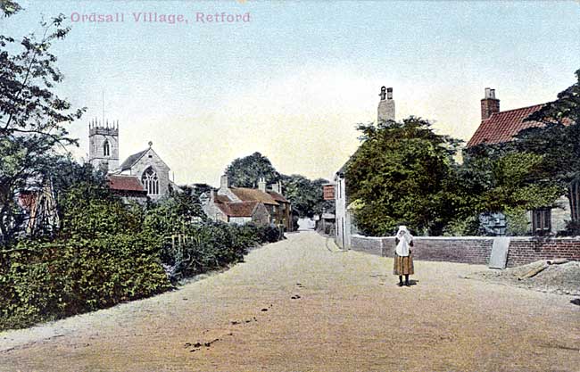
A view along All Hallows Street, Ordsall in 1905.
THE parish for centuries consisted of the village and two small hamlets of Thrumpton and Whitehouses. It was included in the Borough of East Retford in 1878, and now contains the populous districts of Westfield, South Retford and Newtown. In 1831, the population was 809, at which time the houses and the village were said to be "old and irregular, the road hollow and in some places dangerous." In 1861, the number of people had increased to 1911, and there were 462 houses in the parish. The parish rapidly increased until the 1921 Census showed a population of 5,960, and there were more than 1,500 houses. The village is situated in the Hatfield Division of the Hundred of Bassetlaw, which has two other Divisions: North and South Clay. The River Idle here separates the Hatfield Division from the South Clay. In Saxon times North Notts, was the Wapentake of Oswardebec, which afterwards became known as Bersetlaw, and gave its name to the great family of Basset, who owned so many manors in this part of the county. There is nothing recorded about Ordsall before the days of William the Conqueror, and the land in those early times was chiefly marsh and waste, with primitive forest here and there. If there were a few inhabitants here in the year 617, they must have seen the fierce battle which took place near to Eaton (possibly in the fields between the two parish Churches). Redwald, King of East Anglia, defeated Ethelfrith, the king who had usurped the throne of Northumbria. The true King Edwin was under the protection of Redwald, and after the victory, retained his kingdom, and eventually became a Christian, and was baptised by Paulinus in York, in a little wooden Church, on Easter Day A.D. 627. Upon this holy ground now stands the great Cathedral of St. Peter, where people have worshipped for more than thirteen centuries. Christianity first came to our own county through the preaching of Paulinus, who visited Lincoln and must have crossed the Trent by the old Roman ford at Littleborough, and baptised a great number in the Trent near a "town called Tiovulfingacester." No one quite knows where this town was; it may have have been Southwell or Newark or Gainsborough, or quite possibly Littleborough, as the word "town" was used in those days for quite small places.
The name in Doomsday Book, in 1086, is written Ordeshale. In the early documents after this date, it is usually Ordesale. In 1637 we even find it printed on a map as Ardsall, but these corruptions of names are usual everywhere, and very often we find a place-name spelt as it was pronounced at the time by the village people. Mutchmann interprets the name as Ordrices healh—"the valley of Ordric." We shall find this name as one of the owners of land in Anglo-Saxon days.
There are two Doomsday Books, kept at the Public Record Office in London. The large book has 382 pages, and the other one (Eastern Counties) has 450 smaller pages.
In 1083, William the Conqueror levied the Danegeld Tax on all landowners, but it did not yield so much as he expected. The geld-tax had been levied by the Saxon King, Ethelred, the Unready, in order to buy off the Danes. If the country could pay money to the Danes, William saw no reason why it should not pay it to him instead, so he continued the geld-tax. In 1085-86, he ordered a survey of the whole country in circuits. Certain Royal Officers were appointed and they visited each of the Shires, where a great Shire Meeting was held, to which came from every village the priest, the reeve, and six of the villeins. The Commissioners began by selecting a hundred within the shire, and formed a jury of Englishmen and Normans, who should see that the information was correct. The whole country was surveyed in a few months, and all the results were sent to Winchester and written down in the Doomsday Books.
Extract from the Doomsday Book.
The King's Land.
In Ordeshale (there is) 1 bovate of land (assessed) to the geld. (There is) land for 1 plough. There 2 sockmen have t plough and 3 acres of meadow and 3 acres of wood(land). This was in the Soc of the King's Manor of Dunham.
Land of Roger de Busli.
In Ordeshale, Osward, Turstin, Ordric and Turstin had 4 bovates of land (assessed) to the geld.
(There is) land for 4 ploughs. There 2 men of Roger have 3 ploughs and 5 villeins and 2 bordars having 2 ploughs. There (are) 16 acres of meadow. Wood(land) for pannage 1 furlong in length and half a furlong in breadth. In King Edward's time it was worth 28s., now (it is worth) 24s.
In the margin a little further on— In Ordeshale (there are) 1½ bovates. (There is) land for 1 plough.
The Land of the Thegns.
In Ordeshale (there is) 1 bovate (assessed) to the geld. There is land for 4 oxon. Ernui holds it.
THE Doomsday Book is not easy to understand, as the measurements varied a good deal. The expression, "one plough" (or carucate) was the extent of land which a team of oxen could plough in a year. A team consisted of eight oxen, and a "bovate" was 1/8" of a carucate (or plough), being the amount that anyone who supplied one ox to the team could reasonably claim as his share of helping to till the land. Formerly all farm work was performed with oxen, as it is in Bavaria and Spain to-day. It is supposed that a team could plough about 160 acres in a year, and a "bovate" would be nearly 20 acres. A "socman" was a small free-holder with certain privileges. A "villein" was usually a tenant with about 30 acres of land, and the "bordars" were the poorest labourers, with only about five acres of land. So the meaning of the Doomsday entry would seem to be.
The King's Land.
In Ordsall there is a tax-assessment of 20 acres. The King has 160 acres as part of his Manor of Dunham. Two yeomen farm the land. There is three acres of Meadow, and three acres of Woodland.
Land of Roger de Busli.
There was an assessment of 80 acres when four Saxon Squires, Oswald, Turstin, Ordric and Turstin had this land. Roger's two men now farm 480 acres, and five tenants and two labourers have 320 acres. There are 16 acres of meadow. Wood (for feeding pigs), one furlong by half a furlong. In Edward the Confessor's time it was worth (to the Lord of the Manor) 28s. Now (1085) it is worth 24s.
Land of the Thegns.
Tax=produce of 20 acres. Ernui holds these 80 acres.
It would seem that there were about 1,000 acres of arable land in the parish, about 20 acres of woodland, and about 20 acres of meadow. The parish to-day is about 2,000 acres, so we may presume the rest was waste land and marsh.
The King had five Manors in the County, Dunham, Mansfield, Bothamsall, Arnold and Orston. Each of these included several other villages. Dunham Manor included East Drayton, East Markham, Little Gringley, Ordsall (part), Grove, Headon, Upton and Normanton. These were "sokes" of the Manor, and were subject to the Manor Court.
Roger de Busli for a famous person who came over from Normandy with William the Conqueror in 1066. He came from Bully, near Rouen, and received very large grants of land, including practically the whole of North Notts, except the King's Manors. He built Tickhill Castle and lived there until his death in 1108. His son died before him, and all his great possessions returned to the Crown, and were re-granted to various holders. Roger de Busli will always be remembered as the founder of the Priory of Blyth for Benedictine Monks in 1088. The terrible "Harrying of the North" was over. The word "waste" is the only entry found in the Doomsday Book, for one estate after another in the lands between the Humber and the Tees, where once were prosperous Saxon Manors and fields. Roger wished to confer some benefit on St. Catharine's Abbey at Rouen, so he made his Priory a branch or "cell" of the Abbey. Many people think that he employed Norman masons to build the Priory Church, who copied the Abbey Church at Jumieges. All the monks' choir has gone, and their dwellings, but the Nave and North aisle are most interesting relics of Norman days. Curiously enough we know nothing else about this great military chief, who shared with, his Royal Master, the Manor of Ordsall after the Conquest.
"The Thegns" or "Thanes" were Saxon overlords in the Manor, with halls of their own. They were small squires, and were Englishmen who stayed on under the new King, and were allowed to hold land under certain conditions. They did not necessarily hold much land. We read that in Eaton there were ten "Thegns" each with his own hall, and in Headon there were seven. Ernui, the Saxon "Thegn" mentioned also held land in Elkesley, Clarborough, Chilwell, Trowell, Gonalston, Misson and Normanton.
An interesting thing in the Doomsday Survey for Notts is the order that the Foss Way and the York Road were to be specially protected, and the waters of the Trent for navigating passengers and goods by water. The Foss Way ran close by Nottingham to Newark and Lincoln, and the York Road was the road from Nottingham to Blyth and Doncaster, which is now used again after being partly derelict for very many years. There was much boat traffic in the Middle Ages on the Trent, and many ferries. The Torksey people conducted the King's Messengers regularly to York by boat, an no doubt it was for this convenience that the Archbishop of York built one of his palaces at Laneham in very early days.
Nottinghamshire was part of the old Danelaw, and many of the people in the villages were of Danish descent. Wherever a village name ends in "by" (farm) or "thorpe" (village) it is a sure sign of Danish occupation. We have Scrooby, Ranby, Saundby, Harby, Walesby, Barnby, Serlby, all round us, and Habblesthorpe, Perlethorpe, Bilsthorpe and Grassthorpe not far away. The Danes invaded Lincolnshire and burnt down the Saxon Cathedral at Stow in 870, and spent the winter at Torksey in 874, and were at Ripon in 875, and our own county and village must have grievous memories of these fierce and destructive visitors, which made them willing to pay the Dane geld to William I, so that they might live in peace.