< Previous | Contents | Next >
FOREWORD.
There are few Englishmen who are not possessed with a laudable desire to peer into the past history of the place where they live, and it is the aim of the writer of this book to gratify that desire, as far as he is able, by pulling aside the curtain which obscures the Hucknall Torkard of the past from the Hucknallite of the present., acknowledging at once, and with gratitude, the kindness of many friends who have helped him in his purpose.
NAME OF THE PARISH.
The place-name "Hokenhale" and "Hokenale" are two of the oldest renderings of the fore-name of the parish, and may be taken to mean "Oakenhall," the hall in the oakwood. In the ancient Saxon language the oak was variously called hack, hick, heck, and ock; so it is readily seen how easily the fore-name could be changed from Oakenhall to Hucknall in days when printing was unknown in this land, and education limited to the few. In Domesday Book (A.D. 1086) the name appears as "Hochenale." This is only one of many instances hereabouts where the botanical features of the district give the place a name; thus we have Nuthall, the hall in the nut wood; Birchenall, the hall in the birch wood; Farnsfield—from the ferns; Elmton—from the Elms; Sutton in the Ashfield; and even Bestwood, from its varied spelling in the middle ages, indicates that it was derived from beechwood.
Another origin of the name is suggested by Flavell Edmunds in his "Traces of History in the Names of Places." He says, "Huck, Hucken, Eng, is derived from Hucc, the owner's name, and incga, descendants. Example: Hucken-hall (Notts.) now Hucknall." As there is no record of Hucc being a landowner here, the " Oakenhall" origin appears the more likely.
The suffix "Torkard" is clearly traceable to the family of that name resident here 600 years ago, and was probably added in order to distinguish the parish from Hucknall-under-Huthwaite (called "derty Hucknal" in the 18th century), and also from Ault Hucknall in Derbyshire.
An old writer states that "At the Great Rebellion an attempt was made to efface the past by constituting Hucknall Torkard, Papplewick, Linby, and Newstead one parish, but this was prevented."
SITUATION.
The parish is pleasantly situated in the Valley of the Leen, on rising ground midway between the low-lying Trent Valley and the highest land in the county, north of Sutton and Teversall. The Long Hills, which form a spur from the Robin Hood Hills, and are about 445 feet above sea level, are the highest lands in the parish. Hucknall is seven miles N.N.E. of Nottingham ,and eight miles south of Mansfield; it is situate in the Rushcliffe Parliamentary Division, in the northern division of Broxtowe wapentake, in Basford Union district, in the Nottingham Petty Sessional Division and County Court District, in the rural deanery of Mansfield, and in the Diocese of Southwell. The area is 3,275 acres of land and six of water. Wighay Nook is 320 feet above sea level, No. 1 Colliery 311 feet and St. John's Church 224 feet.
PRE-HISTORIC MAN.
No traces have been found in Hucknall of the people of the Stone or Bronze ages, but at Bestwood, not far from Middle Mill, a toolstone was found (a), an implement used by the neolithic man as a ringstone attached to his fishing net, and as a small hammer. No reliable period can be fixed for the neolithic man but some estimate his presence in England at 5,000 years ago. These men tilled the ground, bred cattle, hunted, fished, mined, and made pottery. Stonehenge is believed to have been constructed in the later Stone age.
KELTIC PERIOD.
It is unlikely that Hucknall 2,000 years ago was anything more than a tract of the dense woodland known in later times as Sherwood Forest, the home of the deer, the wolf, and the wild boar.
ROMAN PERIOD.
The Romans formed a great Camp on Cockpit Hill (near Dorket Head) at Arnold (b), three miles distant from our parish, and easily identified as the highest point on our eastern horizon (c). This Camp probably dominated that ancient road to the North, called nowadays the Rufford Road, and was the central military settlement in the district; an imposing Roman villa was built there. The ancient extensive earthworks were until quite recently traceable, and Roman coins have been found there. Twelve years ago a boy named Calladine found a Roman coin near the old footpath to Papplewick, behind Messrs. Mess and Plumb's timber mills. The coin has the impress of the Emperor Trajan's head, and was minted between the years A.D. 98 and 117. Dickinson, in his history of Southwell, gives a map describing the road between Nottingham and Mansfield as a Roman highway. The Roman fosse-way is twelve miles distant from Hucknall. Some authorities believe the road from Mansfield Cemetery over the Robin Hood Hills and north of Annesley Hall on to Derby was constructed by the Romans.
SAXON PERIOD.
After the Romans departed the population in England increased, partly by immigration, and partly by natural means. The great highways constructed by Caesar's legions became more and more useful for the military convoy, and for commercial intercourse. The earlier Saxon immigrants to Notts, fixed upon the fertile lands on the east and south of the county, near the River Trent, the stream yielding to tha invaders a ready mode of access to the Midlands. It was probably towards the close of Siaxon times when a hamlet was founded here, but there is no evidence of a community inhabiting the parish before the days of Edward the Confessor, in whose reign (A.D. 1042-1066) Domesday Book states that Ulchet held land here as well as elsewhere in the county.
Let us picture the Hucknall of those early times.—The forest was cleared around the spot now occupied by the Parish Church, and on that gentle eminence overlooking the stream was reared the first "Hall," from which the parish derived its fore-name. Adjacent to the Hall were a few enclosures used for the rearing of farm stock. Encompassing the enclosures lay the arable land on which wheat, barley, and vegetables were grown. Close at hand were the common pastures which all in the parish who owned cattle were at liberty to use. The fields were bounded on every side by forest, which yielded timber and fuel, and pasture for swine.
The hall, or manor-house, most likely stood a little to the south of the present Church tower. It was a wooden structure, probably formed of the split trunks of trees adjusted side by side, so as to present a flat surface within, measuring forty feet long by twenty wide, one story high, and thatched with rushes. At one end there would probably be a wooden tower erected for defensive purposes, on the south side of the main structure a chapel, and on the north side a kitchen. Small lean-to buildings were joined to the hall, and stables and barns adjacent afforded shelter to the herdsmen.
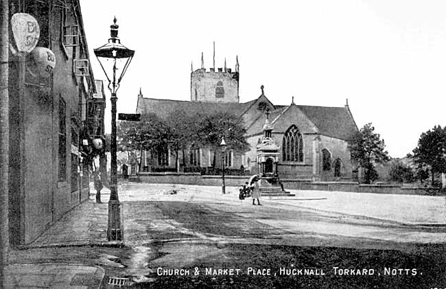
The floor of the hall was strewn with reeds, and the walls were hung with arms and with tapestry woven by the women of the household. The log fire burned on the floor in the centre, the smoke escaping through a hole in the roof. At night a tapestry curtain was drawn to divide the women's sleeping room from the men's, thus the hall was occupied day and night. Near to the Hall, and probably beneath a tree, the parish business was transacted; here disputes were settled, land allotted, and everything arranged according to Saxon custom. The conformation of the ground, the proximity of the Norman-built church, the village green, and the stream below, together with local tradition, support the idea that this gentle hill was the site of the Oaken-hall.
Information as to what happened in Saxon times in these parts is very scarce. Even the laying of the foundation stone of Southwell Cathedral in A.D. 627 by Archbishop Paulinus, of York, is not a fully-established fact. The places nearest to Hucknall where Saxon relics have been found are Nottingham and Oxton, both about seven miles distant from our parish. Tumuli, or burial-places, have been found at those places, supposed to have been constructed in the sixth century.
Near the end of the ninth century the Danes marched along the Rufford Road to lay siege to Nottingham. In A.D. 924 part of the waters of our little River Leen were turned into a big ditch, which the men of Nottingham had dug outside their new town wall by the marshes. This wall, erected to keep out the Danes, was five years in the building. The first bridge over the Trent near Nottingham was also built at this period.
King Canute often hunted in Sherwood, and must have passed Hucknall occasionally. He issued (A.D. 1017) a "Charter of Forest," in which the following clause appears:—" Every freeman shall enjoy the benefit of his own hunting on his own lands, woods, and fields, and to take his own vert (pasture) and venison upon his own grounds, without let or hindrance, so that he should refrain from hunting the King's wild beast (deer) in his own forest."
Whether Hucknall was within the forest boundary in Saxon times is not certain, but in 1231 the forest boundaries were perambulated and the line of demarcation ran through Kirkby and Nun Carre, along Annesley Park Road, "keeping the high road to Linby, through the midst of the town to Lene Water, on to Linton, and thence by the said water as it was wont of old times to run into the water of Trent." The Leen at that time flowed into the Trent opposite Wilford Church, although a part of the stream had been diverted into the ditch beneath the Nottingham town wall.
< Previous | Contents | Next >
(a) To be seen in Nottingham Castle Museum.
(b) Beauties of England And Wales, Vol. XII.
(c) Cockpit Hill is 508 feet above sea-level, and derives its name from the cock-fights
there. This eminence is also called Dorket Head.