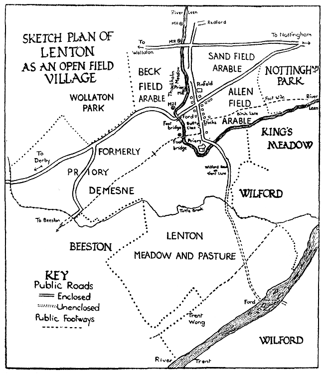
Open Arable Fields.
The three open arable fields were called the Sand Field, Allen Field—called Alwell Field in a survey of 5 Jas.I1—and Beck Field. The Sand Field occupied a large part of the triangle formed by Derby Road, Ilkeston Road and Radford Marsh. In Godfrey's time there was still a considerable tract of arable land lying between Derby Road and Ilkeston Road. Either by accident or design, the short road situated on the south side of Derby Road Methodist Church, and leading to the entrance to the Cottesmore Schools, has been appropriately named Sandfield Road. Lying on the opposite side of Derby Road, and stretching towards Nottingham Park, the River Leen and the village of Lenton, was Allen Field. Beck Field lay to the west of the River Leen. When the fields of Lenton were enclosed in 1768, Lord Middleton was awarded 25 a. 2 r. 8 p. of land in Beck Field, bounded by land allotted to Joseph Stubbins, by the turnpike road leading from Nottingham to Derby, by the Lordship of Wollaton, and by the turnpike road leading from Nottingham through Wollaton.2 It would appear that this piece of land eventually became part of Wollaton Park. Under the heading of "Roads, Footways, Bridges and Fords," mention has already been made of the addition to the park by the purchase of land in 1822 between the old and the modern line of Derby Road. In 1760, this area was probably part of Beck Field, which may also have included land situated on the south side of the present Derby Road.
To the student of English Field Systems, the open arable fields of Lenton are of interest because they form, along with the fields of Radford, an early example of departure from the usual three-field system of the Midlands. This irregularity is pointed out by Dr. H. L. Gray in his English Field Systems. The Jacobean Survey mentioned above gives the names of the six fields of Lenton and Radford as Beck Field, More Field, Red Field, Church Field, Sand Field, and Alwell Field, and the amounts of land held in each. Some persons had land in all six fields ; others in five, or four, or three. Dr. Gray states that the Beck Field, Red Field, and Sand Field, are said to be in Lenton, but that the arrangements of the six fields in groups based on this do not work out happily.3 The extracts from the Lenton and Radford Inclosure Award, 1768, given by Godfrey, leave no doubt that Beck Field, Sand Field and Allen (or Alwell) Field, were the fields of Lenton. An earlier document (1617) quoted by Godfrey,4 makes it clear that Church Field, Moore (or More) Field and Red Field, were the fields of Radford.
Demesne Land. After the dissolution of Lenton Priory,5 the Priory Demesne became separated from the rest of Lenton. The demesne apparently extended from the Priory westward, and included land the position and extent of which the following names will indicate: Nazareth House, formerly a residence called "The Priory"; Lenton Firs, Lenton Hurst, Lenton Abbey, Lenton Fields, Lenton Grove, Lenton House, Lenton Hall, and Highfields.6
Meadow and Pasture. As Lenton enjoyed the advantages of two rivers— the Trent and the Leen—it is not surprising to find meadows for hay in more than one place. It was towards the Trent that the greatest extent of meadow probably lay, but on the banks of the Leen some meadow existed. Thackholme Meadow is marked on the plan. It may be inferred, from the Lenton and Radford Inclosure Award, 1768, that Lenton Pasture was situated between the village and the Trent.7
Trent Wong. The Lenton and Radford Inclosure Award, 1768, mentions this as an old inclosure.8 In the Oxford English Dictionary the following explanation is given of the word "wong." "Wong: obsolete, except in place-names; a plain, field; a piece of meadow land; specially a portion of unenclosed land under the open-field system; now surviving locally in the proper designations of certain fields or common lands."
The position of Trent Wong suggests that it was a piece of meadow.
In a document of the reign of Elizabeth, Prior Wong is mentioned. Its situation near the Trent and the Beeston boundary, makes it appear probable that Prior Wong was an earlier name of Trent Wong.9
Mills. On Chapman's Survey, 1774, three mills are marked in Lenton along the course of the Leen ; one in Radford Marsh, one at the place where Derby Road crossed the Leen, and one lower down the river towards the Priory site. There are still signs of the mill in Radford Marsh, known in Godfrey's time as the Prior's Mill.10 During the last few years building operations have removed nearly all traces of the mill on Derby Road, little more than the name "Mill Cafe" remaining. Records show that a mill existed at this point for several centuries.11
(1) Gray: English Field Systems, 1915 ; p. 104 and p. 533.
(2) Godfrey, p. 322.
(3) Gray : English Field Systems, p. 104 and p. 533.
(4) Godfrey, p. 317.
(5) The prior was executed in April, 1538. See letter from Sir John Markham and others to Cromwell, dated 16th April, 1538.
(6) Godfrey, p. 192, et seq.
(7) Godfrey, pp. 320-323.
(8) Godfrey, p. 324.
(9) Godfrey, p. 29.
(10) Godfrey, p. 11.
(11) Godfrey, pp. 9. 123, 157.