
Margidunum.
A paper read before the Thoroton Society on Friday, January 28th, 1927.
By Felix Oswald, D.Sc., F.S.A., F.G.S.
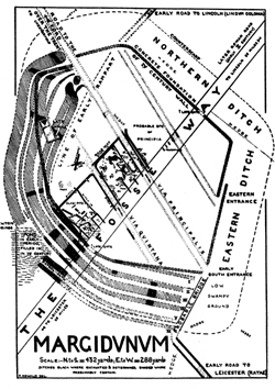
PLATE I. Plan of Margidunum. Click on image for higher resolution version.
THE Roman camp of MARGIDUNUM is situated on the Fosse Way, halfway between Leicester and Lincoln. The site is now covered by three fields, but only one of these is available for excavation since it is fortunately owned by Mr. F. W. Dobson, F.S.A., who has kindly allowed me to dig at will. Progress has necessarily been slow, yet the spade has already revealed much with regard to the origin, history and ground-plan of this camp. When we consider that the Romans occupied our country for almost as long a period as separates us from the reign of Henry VIII, it is obvious that the changes and reconstructions in this camp must have been considerable, and much careful excavation is necessary to fill in the blanks in its history.
In the first place a few words must be said concerning the Fosse Way, the straightest road in Britain, running in a direct course for over 200 miles diagonally across our island from Seaton on the Devonshire coast to Lincoln in the north-east. It seems clear that this road was made during the early years of the Claudian conquest (about 48 A.D.) by Ostorius Scapula as a strategic line across Britain, with forts at frequent intervals (of which Margidunum was one of the most important), in order to protect his flank from the hostile Brigantes and western tribes, whilst operating first of all against the Iceni. For, according to Tacitus,1 he "kept the enemy in check by erecting forts on this side of the Severn and Trent." Subsequently, when advancing against the west country and Wales, this diagonal fortified line would effectually secure his line of communications. The purely strategic character of this early frontier-line is supported by the fact that when the Roman road-book known as the Antonine Itinerary was compiled at the end of the Second Century, large stretches of the Fosse Way must have already fallen into disuse because it did not coincide with a trade-route, for the only mention of this road in the Antonine Itinerary is the small section between High Cross (Venonae) on the Watling Street through Leicester to Lincoln. From this road-book we obtain the name MARGIDUNUM for the camp I am excavating. As a general rule the Romans adopted native place-names for their settlements, and hence we must look to Celtic etymology for an explanation of the name MARGIDUNUM. Its meaning becomes clear if we regard it as the slightly contracted form of Marigidunum, which can be construed as dun, the fort, of ma, the plain (Irish magh), rigi, of the king (rix), i.e., " the fort of the king's plain." Now MARGIDUNUM is situated on a broad ridge of relatively high ground between the Trent valley and the wide, fertile plain of the Vale of Belvoir, in the very centre of the old territory of the Coritani; and traces of an ancient road lead directly from MARGIDUNUM to the dominating height of Belvoir Castle, a likely and suitable position for the hill-fort of the king of the Coritani.
MARGIDUNUM is manifestly an ancient site, and although the Romans cleared it for their camp, I have found sporadic relics of pre-historic times (though in Roman occupation-layers), such as a beautifully worked flint arrowhead, barbed and tanged, of Bronze Age type, a flint scraper of Cissbury type, polished greenstone axes, and bronze socketed-celts of rather late type, one of which is still rough from the mould (Plate II.).
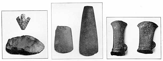
Plate II. Flint arrowhead and scraper, polished greenstone axes and bronze socketed Celts.
The camp was protected by marshes on the south and east, whilst its military value was enhanced by the fact that excellent drinking water can be obtained anywhere on the site at a depth of only 10-12 feet. This underground water issues in the Newton springs immediately south of the camp, where it formed a lake until the Fourth Century when the Romans filled it in and gravelled the surface.2
The early date of occupation of the camp by the Romans is indicated (apart from the positive evidence of finds) by its rhomboidal outline (Plan, Plate I), similar to that of the Augustan camp at Haltern, or of the Claudian camp at Hofheim in Germany, instead of being rectangular as in the Vespasian and Antonine camps at Newstead, the camps on the Roman Wall, etc. This irregularity of outline is due to the military surveyors taking advantage of the contours of the ground, a slight natural valley on the west being utilised for the western ditches.
The camp is 7-8 acres in extent and would accommodate 1,000 men including some cavalry. The southern entrance to the camp was at the S.E. corner and not on (he present line of the Fosse Way, which (as will be indicated subsequently) was a later (Hadrianic) straightening of the original road. The S.E. corner of the camp is near a natural ridge (along which the first road was laid) and is only separated from it by a level meadow where one can still see the camber of the old road to the camp, bordered by a ditch on either side.
My excavations have proved the existence of three parallel roads traversing the camp; the central roadway, the Via Principalis, runs from the entrance at the S.E. corner past the headquarters or Principia to a western gate, whence its continuation, Bridgford Street as it is now called, issued to proceed westwards across the Trent in the direction of Chesterfield, past a camp at Farnsfield and a Roman villa at Mansfield Woodhouse. This road was probably utilised by the Romans to bring lead down to MARGIDUNUM (and thence to London) from the Lutudarum lead-mines situated between Chesterfield and Buxton, for an ingot of lead, weighing 184 lbs., with the inscription: C.IVL.PROTI.BRIT.LVT.EX.ARG. was found at Hexgrave Park near Mansfield.
The road to the north issued from the N.W. angle of the camp and is clearly visible for more than a mile as a ridge or causeway running to the N.E. (parallel to the later Fosse Way), and is still conspicuous enough to be called the "hump" by the farmers through whose fields it passes.
The original defences of MARGIDUNUM comprised no less than six ditches, testifying to the hostile nature of the surrounding British tribes when the Romans occupied the site.
The V-shaped ditches appear to have been separated from each other by entanglements of stakes, for I have found post-holes on the platforms between the ditches. On the south side of the camp (and probably all round it) there was a well-gravelled road between the two outermost ditches, perhaps a patrol-path for sentries, a very necessary precaution against a surprise on foggy nights. On the western side of the camp the inner ditches are interrupted by a large bath-house, which I have only recently discovered and to which reference will be made later on.
The rampart itself consisted of timbers backed by earth, and was at some period destroyed by fire, for I found charred beams on the south side of the camp. Post-holes indicate that it must have resembled the wooden ramparts, backed by earth, of such early forts as Haltern. In a country, which was then thickly forested (as shown by the frequent remains of wild boar and red deer), such a palisade was rapidly constructed and easily repaired. But it is possible and even probable that the gateways were built of stone ; for in a very old ditch (draining an inner ditch just behind the southern ramparts into an outer ditch) I found (associated with early "Samian" ware of Claudian age) three stones of a narrow arch or window, which have the same characteristic outer moulding as in the windows of typical Roman gate-houses such as at Saalburg on the German limes (Plate III.). The carefully dressed and tooled stones (of Millstone Grit), brought from a considerable distance (perhaps from Castle Donington), have been much cracked and calcined by a fierce fire, as well as blackened on the outside when the flames burst through the arch.
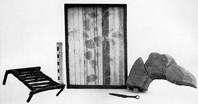
PLATE III. Gridiron, wall plaster, stone arch.
Since these stones had been thrown away into a ditch containing early pottery (not later than the first years of Nero's reign), it is tempting to connect this occurrence with the disaster which befell the Roman arms in the Boudiccan insurrection in A.D. 61, when the Ninth Legion (then stationed at Lincoln) was cut to pieces whilst hastening to the aid of Verulam and London, and only a remnant of the cavalry, with their commander Petilius Cerialis, was able to reach its base at Lincoln, and in order to do this they must have galloped through MARGIDUNUM, which would no doubt have been destroyed by fire by the pursuing British.
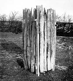
PLATE IV. Oak-lining of Claudian well.
The fort would soon have been re-occupied and re-constructed after the decisive victory of Suetonius Paulinus, when "he made a desert and called it peace." The ditch just behind the wooden rampart (backed by earth) was filled up together with the Claudian well that was situated in this ditch. This is the oldest of the wells I have cleared out at MARGIDUNUM, as proved by the pottery it contained. The later wells were lined with stone, but in this instance a square casing of oak planks was lowered into the well, and clay was rammed round this casing so as to reduce the diameter of the well from 6 feet to 2 feet. The planks preserved in the lower part of the well are still sound, after 1,880 years and even show the marks of saw and adze (Plate IV.).
(1) Annals, XI 31, 2, i.e., on the east of the Severn and the Trent.
(2) A coin of Magnentius (350 A.D.) in mint condition occurred on the surface of this gravel.