
Nottingham Town Wall.
By Mr. A. Stapleton.
THE old-time Nottingham historians made frequent mistakes that present day facilities for investigation would have prevented, and in their accounts of the Town Wall, not only do they display no knowledge of the pre-Norman lines surrounding St. Mary's Hill, but, following the lead of Camden and Speed, they wrongly identified them with the municipal defensive system of post-Norman times, and also fell into numerous errors as to the date, extent, etc., of the wall of stone. Having had this interesting subject under review for some years, I may perhaps be able to correct a few time-honoured misconceptions.
First, with regard to the oft-mentioned triangular northern extension or projection of the Parliament Street line of works to the hill-top in what is now Goldsmith Street, an inspection of the site thereof certainly suggests military method, and the best practical account of this extension will be found in the late James Shipman's book on the Town Wall. Whatever its history, this feature has been overrated in the past, insomuch that observance of the rule of proportion precludes more than passing reference here. It must suffice to say that the angle in question was a compartively narrow and shallow earthwork, exhibiting no traces of stonework, influencing no road-lines, nor otherwise affording evidence of former importance ; and finally that, so far as can be seen, it may well have been no older than Carolean Civil War times.
It is a common mistake to associate early castles and defensive walls with stonework,—a development that did not begin to supersede earthwork until about a century after the Conquest,—all the castles mentioned in Domesday Book, for instance, being earthworks. Hence, not only was the latter the true character of the so-called "Edward the Elder's Wall," (a construction now known to have been centuries older), but the Norman castle of Nottingham, as well as the town defences (presumed to be likewise of Norman origin) to which it was linked, were undoubtedly earthworks in the first instance. Evidence of the building of a wall of stone around Nottingham does not commence to appear on authentic record until just two centuries after the Conquest.
I am aware that the late James Shipman did not subscribe to the view that the wall of stone was reared on the inner rim of a pre-existing ditch,—although himself chronicling discoveries of Norman pottery in the latter. There is, however, the obvious improbability of this important royal borough adjoining the impregnable Norman castle being left unenclosed in complementary lines, plus the significant circumstance that when St. John's Hospital was founded, in the middle of the 12th century, it was placed, as customary, immediately outside the town defences. Furthermore, there exists some little documentary evidence. The Thurgarton Cartulary contains an early, undated grant of land lying next to land of the Hospital of St. John, and described as situate "upon the New Ditch of the town of Nottingham,"—a term that may have been adopted in contradistinction to the older ditch around St. Mary's Hill. Again, the "Borough Records" chronicle a grant to St. John's Hospital, by the widow of a man who died in 1242, of rent from land in "Barregate,"—a street-name that appears to indicate a gateway, perhaps of wood, in the earthen defence lines. (Perhaps the street in question was the later "Swinebargate," which embraced Coalpit Lane and the inner or south side of St. John's Street.) Finally, a recent calendar of Patent Rolls supplies this note:—8 August, 1260. "Protection,with clause rogamus, for seven years, for the Friars Hermits of St. Sepulchre's without Nottingham." The religious institution in question was probably identical with St. John's Hospital, and in any case, so far as I am aware, mediaeval references to sites "within" or "without" given towns, occur only in implied relation to defensive lines.
However, although palisaded earthen defences were doubtless better than none, their shortcomings were forcibly brought home to the burgesses during the virtual anarchy of the Barons' Wars, in the course of which Nottingham was thrice sacked and burnt. Whether in consequence of these sanguinary experiences, or because it was becoming the contemporary practice, the project of adequately fortifying the town with stone walls and gates was seriously taken in hand, and to this more definite phase of the subject I now pass on. District rates, town improvement acts, and public loans being alike unknown, and Nottingham being a royal town, the burgesses followed the then orthodox plan for raising the requisite funds, of obtaining successive royal licences, for terms of years, to levy "murage" tolls on merchandise entering the town. Here are the four earliest allusions I have been able to find:—
51 Henry III. (1266-7). Murage for the town of Nottingham.
54 Henry III. (1269-70). Murage for the town of Nottingham. (The two foregoing notes are from the old folio calendar of Patent Rolls, now being superseded by the State Papers, which latter do not as yet cover the above period. Terms of years not stated).
18 October, 1271. Royal precept (vide Thoroton) commanding the burgesses to build a Postern in the town wall, near the castle, towards Lenton, of breadth and height adequate to admit the passage abreast of two armed horsemen carrying lances over their shoulders, in the place appointed by Archbishop Walter Gifford of York, (at that time constable of the castle), "who made the king understand it was expedient for him and his heirs, and for the castle and town."
29 May, 1275. Murage for the town of Nottingham for five years. (Modern calendar of Patent Rolls).
It is apparent that the building operations commenced by a juncture with the outer castle wall, and from that point were continued down what we now call Park Row, and thence along Parliament Street; the pre-existing ditch being probably at the same time re-cut, or enlarged. Without citing them in detail, it may be added that, except for one or more breaks, the royal murage grants to the burgesses of Nottingham continued well into the first half of the 14th century. In 1332 the king suspended the collection of murage during the remainder of the term of a royal grant to Alice le Palmer to collect "pontage" for building the Trent Bridge, in consequence of complaints that dues were being levied for both objects on the same goods. In February, August, and October, 1333, there occur notices of royal commissions touching the accounts of murage collected at Nottingham. On 12 October, 1334, there was a grant of murage to the mayor and burgesses of Nottingham for three years, which is the latest notice found, and brings us down to the year 1337, or fully seventy years from the beginning of the work. Hence we may now point to the definite period, 1266-1337, as that of the erection of the stone walls and gates of Nottingham, so far as the project was carried out. As the funds came to hand but slowly, the progress of the work was also slow, while towards the end it was not unlikely prosecuted with flagging or grudging spirit, as a costly undertaking yielding no return ; and one that is not recorded ever to have served the burgesses any useful purpose. Be that as it may, but a few more years elapsed before the terrible devastations wrought by the Black Death, (which effectively stayed all great building operations), and the succeeding period of stagnation, probably removed any lingering chance of resuming the works. Our old local historians, who, having seen portions of the bygone wall, very naturally supposed it had originally surrounded the town, are not safe guides hereon.
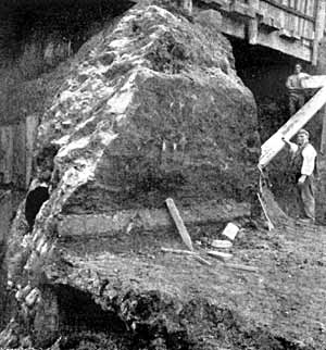
Front of the old town wall in Lower Parliament Street (c.1899)
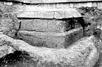
North-east corner of a buttress in the old town wall, opposite South Sherwood Street.
At this juncture it may be well to pause and glance at the architectural character and magnitude of the wall, as revealed by excavations under Parliament Street in 1897-8, and chronicled by Shipman, (to whose book reference should be made by such as desire fuller particulars). The Central Railway cutting, twenty-seven feet in depth, extended well below the foundation of the wall, and exhibited the manner in which the latter had been mitred into the rock. The thickness varied from six to seven-and-a-half feet, below the plinths, of which there were two, both embraced within a height of from seven to ten feet above the base, the thickness of the wall being, of course, reduced above the plinths. The railway cutting,—which involved the baring, in the aggregate of no less than thirty-six-and-a-half lineal yards of the wall, —revealed at its western limit the greater part of a huge semicircular buttress, which almost doubled the thickness of the wall there.
A square buttress, revealed by subsequent excavations opposite Sherwood Street, was found to extend no less than nine feet in advance of the face of the wall proper. Except for the more exposed plinth-courses,—wrought in Mapperley Hill stone as possessing greater durability, and perhaps an occasional stray fragment of the same material,—the whole of the wall and buttresses brought to light were found (as on all previous occasions) to be built of blocks of Nottingham sand-rock, the largest of which measured twenty-four by sixteen inches, extending in regular courses through the wall. Although a coarse mortar was found to have been pretty freely used on the face, the stonework of the whole of the interior and rear of the wall was bedded only in clay. With regard to perpendicular dimensions, the base of the wall was found to extend no less than twenty-one to twenty-three feet below the surface of Parliament Street, while at one point rising to within eighteen inches of the street level. Thus the revealed remains may be described as roughly twenty feet in height, about one-half of which Shipman computed to have been originally above ground. To this, of course, needs adding the long-destroyed upper portion of the wall, the extent whereof we have no means of computing. If, however, we only add the moderate estimate of one-half the buried portion, some idea is gained of the magnitude of the task the mediaeval town authorities had in carrying the massive structure to a height of thirty feet,—and it may well have been more. Even the imperfect, revealed portion was sufficiently imposing and impressive to momentarily stimulate the imagination of the ordinarily prosaically scientific observer, Shipman, who wrote:—"Taking it altogether, the old wall was a sight that far surpassed all my hopes of ever witnessing, in connection with the antiquities of Nottingham. I had often longed to get a view of the old town wall, in some excavation or other, but never expected that I should live to see it. And what a picture the wall, with its moat and other adjuncts, enabled one to conjure up of what Nottingham must have been in the Middle Ages!" It may be well here to add that the latter writer found the town ditch in Parliament Street to measure from thirty to thirty-five feet wide, and to extend to about twenty-two feet below the level of the street. It may be pointed out that, although Shipman occasionally used the word "moat," all the defensive ditches of old Nottingham, from their situations, were necessarily dry ones.
It will now be well briefly to review the evidence bearing on the interesting question of the actual extent of the wall, in the light of modern knowledge.
To begin at the beginning, although the situation of the comparatively short west wall, within private property lines and removed from highways, has prevented it being revealed by public excavating operations, the three grounds of probability, documentary references, and testimony of old maps and topographical works, form a sufficiently strong combination to preclude question as to its due existence and completion. The complementary dry ditch here, called "Butt Dyke" down to its filling-in about 1800, retained in Deering's time the tradition that it had been formerly utilised for archery practice,—a tradition confirmed by a reference as early as 1351 to the "Buttes in the Dikes outside the Walls."
As early as 1308 occurs the first reference in the "Records" to the "Westbarre," otherwise the Chapel Bar gateway; while the first reference to the "Northbarre," otherwise the Cow Bar, is met with in 1335, when one, "Richard Attebarre," dwelt by it. While these two allusions might perhaps be considered to approximate in date to the assumed period of the operations, it is essential to remember that the occurrence of place-names in surviving property deeds, etc., is fortuitous, and proves nothing beyond their existence at the corresponding dates.
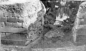
The old town wall cut through at the top of Market Street in 1866.
Passing along to the north wall, I am not aware that any writer or student has hitherto questioned its full completion to its limit, at the Swine Bar, which evidently stood at the foot of Heathcote Street. On the available evidence, however, the present writer (who has perhaps seen as much of it as anyone now living), entertains grave doubts whether more than one-half the length of the projected north wall was actually built. The nearest point to Chapel Bar at which I have seen the wall exposed was under the causeway of the Three Crowns Inn and adjoining shops, some few years ago, while the electricity supply was being laid. A good section was exposed and photographed in 1866 at the top of Market Street, in front of the existing statue. In December, 1908, I saw the wall exposed just eastward of the statue, while water mains were being laid across the top of Market Street, immediately south of the unused line of tramway-rails. Another good section, comprising a fine square buttress, and evidence of about thirty-two lineal feet of foundations, was revealed and cut away in the work of constructing the underground convenience between the upper ends of Market Street and Queen Street, in 1898; particulars of which were placed on record by Shipman. There appears to have been no evidence of the wall ending here, so that, on the above, plus documentary testimony, the existence of the wall may be reasonably conceded from Chapel Bar to Queen Street. From the latter point, however, to the Cow Bar, at Clumber Street end, I have neither heard of nor personally observed any wall foundations, although I have more than once seen the ground turned up to a considerable depth along the supposed line. While this evidence is by no means conclusive, it nevertheless gathers weight when coupled with the following documentary testimony :—
1352. A messuage in the Saturday Market described as extending from the king's highway on the south to the Ditch of Nottingham on the north. ("Records.")
1487. A messuage upon the "Long Roo" described as abutting upon the " Saturday Markett" and the "Common Dyk" of the town. ("Calendar of Ancient Deeds.")
1547. A tenement or burgage on the Long Row, lately belonging to Dale Abbey, described as abutting upon the king's highway called "the Merke Steede" on the south, and the Common Ditch of the town, called in English "the Towne Dike of Notyngham" on the north."