The Old Streets of Nottingham.
By James Granger
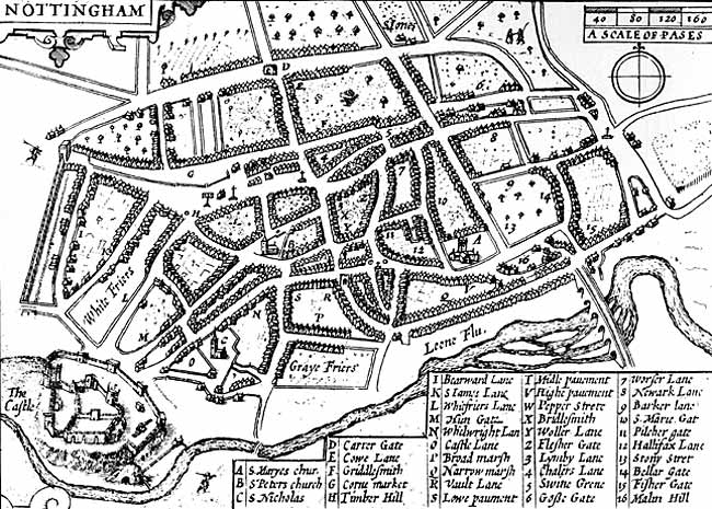
John Speede's map of Nottingham (1610).
RESPECTING the title of this paper there may possibly be some doubt as to its strict relevancy, and to many the explanation will doubtless be somewhat surprising. Almost within the time of the grandparents of a few who are still living, the "Streets" so-called of the town, were exceedingly limited in number. On Speede's Map dated 1610 two "Stretes" only are referred to, the remainder being "Gates," Lanes, &c. The streets were entitled "Stonestrete," "Stonstrete," &c, and "Pepper Strete," "Peperlane," "Pepirstrete," &c. The first probably dates back about 680 years and the latter close upon 600 years, Thoroton's history is dated sixty-seven years later than Speede's Map, or in 1677, and in that work the number of streets is made three, by adding "Finkhill Street." I am quite willing to believe that some would not have supposed this to be the case, but it is plainly numbered and named; still, as a street, it is far from central, as regards the old town.
The next reference to our streets is about seventy years later than Thoroton, being near the year 1747, and is made by Deering in his History of Nottingham. Six streets are then noticed, namely:—Stony Street, Pepper Street, Finkhill Street, High Street, Queen Street, and Turnbull Street. The latter appears to have been but little alluded to or known after Deering's time, and strange to say, no reference to it will be found on Deering's Map. My older readers will be reminded of Turncalf Alley.
Respecting High Street, Thoroton on his Map (No. 54), entitles it "Sadler Gate."
The Borough Records at present come down from 1155 to the year 1702 only, and though many eminently useful and interesting particulars may be collected therefrom and of value to the antiquary, I have observed no reference therein to Sadler Gate. Deering adverts to this roadway on few occasions, but on page 14 it is introduced amongst a number of others, which he considers had obtained their names from the various trades carried on therein.
Going back three to four hundred years, I have at various times seen reference to "Hencross Row," which no doubt proves that it was near to the old "Hencross," once at the top of what we now know as the "Poultry." The large block of property, of which the Exchange is a portion, and going back from the Market Place to High Street, was in Thoroton's time (about 1675) very different in character to what is at present the case. On his map a street is shown running through it from north to south, and another from east to west; that is from what is now called High Street to the market-place. The latter, from the market to the cross-lane, is called Fish Shambles, and the remainder to Sadler Gate is entitled "Shamble Lane." This street divides the property into two parts on that side of what is now termed High Street. On the eastern or opposite side of the way, there was a complete line of houses or other buildings, according to old maps, reaching from Gridlesmith-gate (now called Pelham Street) to Bottle Lane (entitled Linby Lane by Thoroton). On various occasions Hencross Row is referred to, and I have no doubt whatever, that the line of houses mentioned, was in former times, termed "Hencross Row," and this I am decidedly of opinion was at one time the chief name even for that thoroughfare, the houses being mainly on that side. In the Borough Records, vol. 4, page 438, "Hencross Row" is mentioned in 1583, and on page 440 under the heading of "Panyer" we are told that "A.D. 1552, William Rose brings a writ of right against Joan Stapleton, widow of John Rose, regarding the messuage known as 'le Panyer' in Hencross Row." I should have been glad if the editor of the Records could have given us a few more details relating to "Hencross Row," from the old muniments of the town.
The third and last of the new streets between 1677 and 1747 is "Queen Street." I have no doubt that this name originated with Queen Anne, for it was unknown to Thoroton 1677, but as regards the roadway with our present day ideas, it seems strange that it was then termed "Street." Many are still left in Nottingham who will have a full recollection of Queen Street in its "original" state, more than fifty years since; when it was a contracted and flagged footway, but little if any more than two yards wide, connecting Fletcher Gate, Warser Gate, and Bottle Lane with Pelham Street, Carlton Street, &c. From these remarks it will be understood why exception is taken to its name; for "street" implies generally a thoroughfare for vehicular, and all other sorts of traffic, for which the original Queen Street was not qualified, and in that respect I believe it to have been exceptional in the town. An old townsman agrees with me that posts were fixed at one, if not both ends of the way.
Generally speaking, the knowledge of Queen Street as it was full half a century since, is far from prevalent, and there is a proneness to imagine that little or no change has occurred in living memory. Respecting this, the Editor of the Borough Records, vol. 2, page 442, falls with others into an error. He says, when speaking of Linby Lane, "the common lane mentioned at page 359 (in 1435) as going out of Walsed (=Warser) Gate into Chandler Lane is the 'present' Queen Street." This is no doubt incorrect. Volume 2 of the Records was published in 1883, and probably what we are there told, represented the belief of a large portion of the community at that date; still it is certainly desirable that such a mistake in an official work should be noted and rectified. By terming this ancient roadway "Old Queen Street" and giving the name of Queen Street to the thoroughfare in which the large new post office has been built, we shall certainly in time add to the confusion which has arisen.
Of the six "Streets" mentioned by Deering four have been noticed, but of two, Stoney Street and Pepper Street, there appears to be little known as regards the origin of their appellations. From this it will be perceptible to all, that to restrict my subject to "Old Streets" specially, would confine it within very limited bounds; I therefore propose to include other thoroughfares of interest, whether they be termed gates, lanes, or roads, and possibly a few with other designations. Respecting what we style "gates," I have no doubt that an inaccurate idea prevails with many persons as regards the old town. They consider that "gate," at least in an ancient town, implies a connection with an opening in the wall surrounding it, but whatever may be the case in other places, the notion is thoroughly incorrect as regards Nottingham.
In the Borough Records, Vol. 1, page 432, the editor tells us that "Gate," in the Nottingham street names, means "a road or way," and circumstances prove the accuracy of his statement. References may be found to several openings in the old wall or fortifications, including "posterns," but of those for ordinary traffic we have little or no information excepting two, namely:— the opening at the bottom of Tollhouse Hill (now Derby Road), which was styled Chapel Bar, and the avenue we now term Chapel Bar was for some time after the publication of Deering's History in 1751, entitled "Bar Gate." This outlet in olden times is also frequently designated the "West Bar."
The other main outlet was Cow Lane Bar, with numerous variations of spelling in former times. "Cow Lane," after being widened full sixteen feet about 1812, but especially at its southern end, was then renamed "Clumber Street." On Speede's Map dated 1610, Cow Lane or North Bar, is shown in the centre of "Backside," or as now called "Parliament Street," which of course was its proper place, for the town wall passed down there, near which and in that street, portions have in recent years been several times exposed. Cowbarre or Cowlane Bar (see Records, vol. 5, page 260), was ordered to be demolished by the Corporation in 1649, therefore Thoroton does not show it on his map in 1677; but the West or Chapel Bar is plainly to be seen. It was pulled down in 1743. See Deering, page 3.
Including "Gridlesmith" and "Bridlesmith," Speede (1610), gives a list of ten "gates" only, but he mentions "Whelwright" Lane, Castle Lane, Barker Lane and Worser Lane, which by Thoroton (1677) are termed "gates." He also enumerates fourteen "lanes," including the four whose names are previously given. Speede refers to "Swine Grene," which Thoroton entitles "Swine Gate," and in so doing I consider he is wrong; judging by the large amount of valuable information now to be found in the Borough Records, which in some matters, as being official, is I think preferable even to Thoroton, whose home was about twelve miles from the town. Speede mentions thirty-five passages of various kinds upon his small map of Nottingham. In Thoroton's Nottinghamshire is a larger and more reliable map of the town, on which will be found a list of eighty gates, lanes, rows, streets, localities, &c, amongst which are nineteen "gates," including Sadler Gate, now High Street Gridlesmith Gate now Pelham Street, Swine Gate (which I consider improperly so named) now Carlton Street, and Mont Hall Gate, which reached southwards from the lower end of Pilcher Gate, or upper end of Byard Lane and the eastern end of Middle Pavement. It was after, wards termed Blowbladder Street, Market Street, and for a time Old Market Street. It is now included in Week-day Cross, which has been extended to the lower end of Fletcher Gate (entitled Flesher Gate by Thoroton); Lister Gate was Litster Gate, and Hounds Gate was Hundgate.
He also refers to twenty-eight lanes, of which Chesterfield "Lane" is changed to Street; Walnut Lane is Walnut Tree Lane; Wooller Lane was afterwards Moot Hall Gate; the top part of the street was known as Friar Lane, but subsequently became Park Street; and Friar Lane was substituted for Moot Hall Gate. St. James Lane is now a Street, Bearward Lane has become Mount Street, Cow Lane as previously stated, after being widened, became Clumber Street; Linby Lane (a very suitable name) was changed, with great lack of thought, to Bottle Lane; Halifax Lane for some time after was known as Jack Nuttal's Lane, and then as Halifax Place. Mont Lane became Middle Hill, and Vault Lane, Drury Hill; Broad Lane was changed to Broad Street, and Newark Lane afterwards became Sneinton Street.