The Precincts of Nottingham Castle.
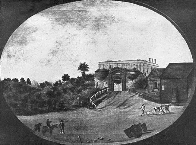
NOTTINGHAM CASTLE LODGE. (From an old Painting in the possession of Dr. Thos. Wright.)
THE Council made arrangements for an inspection of the surroundings of the Castle, on the afternoon of the 27th of July, 1904, when some seventy members assembled at the Castle Gateway at 2.30 p.m. Mr. Wm. Stevenson, of Hull (formerly of Nottingham), kindly undertook to act as guide on the occasion. Before starting the party assembled in the Drill Hall, where Mr. Stevenson explained that it was his intention, that day, not to follow the beaten track of written history, or to call attention to anything within the enclosure of the Castle, but to endeavour to interest the members in the unwritten history of its precincts and the Castle Rock itself. He asked them mentally to view this great sandstone rock, terminating suddenly at its southern end, as it appeared thousands of year ago, before any earthworks, or buildings, much more any stronghold, were placed upon it; in other words, to view it in the state in which nature formed it, viz.: high and steep on its western side, precipitous on the southern side, easy or undulating on its eastern side, and level on its northern line. Such a place, naturally defended on two sides, would be one of the first to be seized upon as a place of safety by early man, who would artificially defend it on the weak sides by ditch and bank. This he no doubt did in a primitive way by cutting a trench, east of the ridge, from the cliff where Castle Terrace now stands to the top of St. James's Street, thence slanting it off westward through the present Hospital Buildings to the top of Park Row, where that street joins the Ropewalk. There is undoubted evidence of such a work having been accomplished, and, although it has played little or no part in history, it was a work of amazing magnitude, and must have occupied a long time in making, before it accomplished the object for which it was designed; and it is marvellous that in its period of decay, it should have been so completely obliterated as it is to-day, when it appears merely as a slightly sunken road and a parish boundary. Even its old name "The Hollows," which survived till the first quarter of the 19th century when the Standard Hill property was built upon, has been lost.
Throughout the whole of its line from the east end of Brewhouse Yard to the top of Park Row, this great earthwork is rated as a hundred, a manor, a county, and a parish boundary. It is outside the mediaeval castle, the south or lower part being utilised as its eastern defence. Its north or higher part has long been filled up, and used as a public road; its day as a great line of earthern defence must have passed away a thousand years ago.
Our first authority on this great work is the late Rev. James Orange, in his "History of Nottingham" (vol. 1, page 477), who, speaking of the above neighbourhood, says:—" There is a ditch opposite the top of St. James's Street, the eastern terminus of which may be discovered by anyone going along the Hollows; for a little above St. James's Church, in the wall bounding that side of the road, just at the southern extent of the hospital pleasure ground, the crown of an arch rises about 8in. above the flags, which, when this wall was built, it was found necessary to spring, because there was no substantial foundation. This was part of the ditch which stretched north-west from this place, extending under the new western wing of the hospital, and terminated where the old postern used to stand." He further says (alluding to the west end of Hounds Gate), "About 1797 after the workmen had dug down 14 ft., they came to a solid cart road which used to be the surface. This accident supplies us with the means of ascertaining the depth of the ditch outside the castle walls eastward."
The second authority is the late James Shipman, F.G.S., who wrote a work, "Excavations at Nottingham General Hospital" (Nottingham: F. Murray, 1899), and furnishes plans, sections, and text, illustrative of the subject, connected with the recent erection of the great circular ward of the General Hospital. The cost of the foundations was materially enhanced, as they struck into two ditches, the greater one 50 or 60 ft. wide; the a smaller one on the north side, a few feet distant, about 13 ft. wide. The depth of the former is about 33 ft. below the present level of the lawn, 8 ft. of which has been added above the old road surface since the site was adapted for hospital purposes. The depth of the latter is about 17 ft. below the present lawn surface, 8ft. of the covering was found to be modern, reposing on an old road pavement. "The ground was all loose soil; the ditches followed a general east to west line, and cut across the top of the hill-side."
The south end of this great ditch is not obliterated by filling in, and is now known as Castle Road.
The northern end of this great pre-historic earthwork was the point from whence the manor line, now called Park Row, was drawn; this was a ditch and bank, improved as time went on and the science of military engineering developed, with a wall of stone and an impassable moat. The northern part of the enclosed area was a grass field, which in the middle ages was made historic as a camp, in the midst of which King Charles I. raised his standard in 1642, and ventured his all on the fitful chance of war.
In connection with this enclosure, it may be mentioned that the town ditch terminated westward at its northern point, and here was situate the "postern bridge," of Edwardian origin, a name that wore down on the tongues of our fathers to Boston bridge, a construction rudely figured on the first map of the town, dated 1610, but by an evident error placed on the wrong or inside line of the wall.
We have no details of this postern itself, unless we identify it with that named by Thoroton (p. 490), when the walling of the town was decided upon; for Henry III., in the last year of his reign (1272), at the instigation of Walter Giffard, Archbishop of York, then the custodian of the Castle, commanded "his Bayliffs and Burgesses of Nottingham, without delay, to make a Posterne in the wall of the said Town, near the Castle towards Lenton, of such a breadth and height that two Armed Horsemen, carrying two Lances on their shoulders, might go in and out, where W. Archbishop of York had appointed it, who made the King understand that it was expedient for him and his heirs and for the Castle and Town." If this be accepted, it was a construction as large as the existing Castle entrance itself.
The site of the present north gateway of the General Hospital, facing the Ropewalk, fairly represents that of the departed postern, a spot where the three parishes of St. Mary, St. Nicholas, and Standard Hill still join hands.
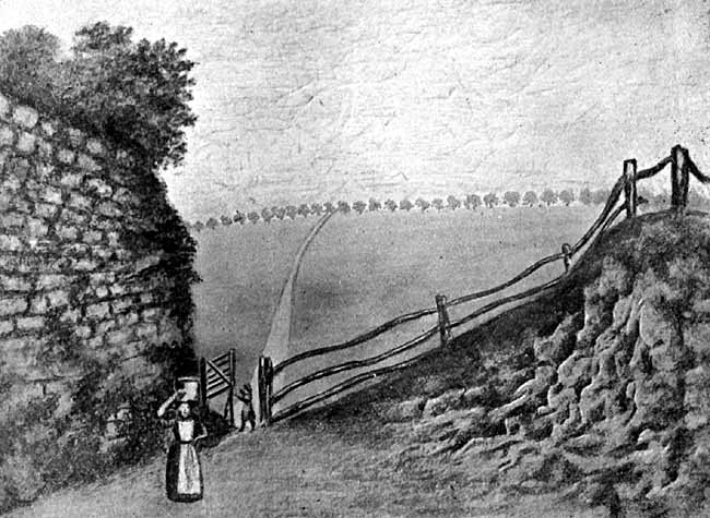
PART OF WALL OF MEDIAEVAL CASTLE.
(From an old Painting in the possession of Dr. Thos. Wright.)
Mr. Stevenson then proceeded to call attention to the Castle bridge, which led to the outer gate of the mediaeval fortress, a construction still largely original, and clearly about 600 years old. He pointed out that the outer face of the great arch is chamfered, and a corresponding detail may be traced on the opposite end of the arch. The bridge is constructed of local material on the weak system of ribs, and the arch is therefore wanting in lateral strength; a fault the old Trent and Leen bridges suffered from.
The small (or western), arch in its original state, had end-walls, the springers of which remain, and a vault covered by the draw-bridge.
The old fabric now fulfils the useful office of a retaining wall for the modern road to the Park. It was very different when Thomas Sandby made his drawing "An East Prospect of the Castle" (Deering, p. 176), as an embellishment of the celebrated map of 1744. This was the first artistic work produced by a townsman, a fine copy of which, possibly unique, has been added to the collection of art treasures in the Castle.1
Over this bridge has passed, many a caravan of sheriffs carts, laden with stores of food, etc., for the defenders of the fort; the hostages of war from Wales and Scotland; breakers of forest laws; prisoners of war, and those charged with high treason, many of whom were ordered by various kings, or their state officers, to be securely kept in the deep dungeons, and not allowed to escape at the peril of life and limb to the old constables. It has also seen the arrival and departure of nearly all our kings, from the great Edward to the martyred Charles; it has borne their regal retinues and martial hosts, whose arms have glittered in the sun. In later times it became the highway to the Cavendish palace that succeeded the old fortress, and over it passed the state carriages of the noble owners, who were rated amongst the best horsemen and the most stately chariot-owners in Europe.
Drawings of this part of the Castle precincts have been made on several occasions. One by Caroline Mary Price, dated 1830, in the Castle collection, shows the main arch of the bridge utilised as a cottage and the western one as a stable.
A little south of the lodge formerly stood an inn or tavern, the name of which is lost. Its cellars ran west under the grounds of the Castle; no record of its demolition exists, but the doorway, originally leading into the cellars, is shown in Sandby's picture, already noticed. The latest reference to it is by the late William Stretton, a gentleman to whom the historians of the city owe a debt of gratitude. It is as follows: "A few yards south of the Castle lodge stood a public-house in the Rebellion of Charles I. The cellaring was opened in 1816 and I descended therein, when the stables behind the Riding School were erected." (Stretton's copy of Deering in St. Mary's Church, p. 176). At this point, part of the Castle wall was taken down and rebuilt further back, when the Nottingham troop of Yeomanry built the Riding School in 1798.
John Blackner, our local historian, ninety years ago, said of this Riding School: "Equestrian and vaulting exercises are sometimes exhibited here by troops of strollers who occasionally visit the town. This is a nuisance that has long been complained of, and over which the town magistrates have no control, because the building is without their jurisdiction.1 These strolling swindlers generally find the means of putting off a large quantity of base silver, and the folly of the people enables them to take a larger quantity of good money away."
The members, after this opening explanation by Mr. Stevenson, left the Drill Hall and proceeded down Castle Road, where the bastion, which is shown in Thos. Sandby's picture, on the map of 1744, and in John Hicklin's History of the Castle, 1834 (p. 150), is situated.
This bastion is remarkable in being wholly built of Nottingham sand rock. The outer face has perished by exposure, and in the upper part nothing but the inner shell remains. The fallen material has buried the lower half, which is no doubt in a fairly perfect state, and if cleared away would give exact data for its restoration. It is an early Edwardian work contemporary with the entrance gate of the Castle.
There was a similar bastion at the corner of Brew-house Yard. It fell in 1832, and was rebuilt on a smaller scale.
Attention was called to the quaint row of old cottages on the opposite side of the way, built on the waste or open land of the town, in 1729, by the overseers of St. Nicholas, as the workhouse of that parish, which was abandoned in 1813 for more commodious premises at the bottom of Park Row. This old property, a neglected picture of Nottingham, was the first range of buildings erected on Gilliflower Hill, the old name of the Castle Terrace district.
There is a large oil painting in the Castle gallery labelled: "Nottingham Castle and St. Nicholas' Church, painted about 1760, given by his Grace the 7th Duke of Newcastle," that shows a back view of this old building, with its long line of roof. For eighty-four years it raised its humble front as a foil to that of the stately Castle.
(1) By the courtesy of Dr. Thomas Wright, of Castle Place, we have been permitted to reproduce two old pictures, one of the Castle Lodge and one of the Castle Wall, shewing the old track leading to Lenton. Jt. Editors.