
THE WALLS OF NOTTINGHAM.
By J. G. N. CLIFT, Esq., Hon. Secretary.
(Read at the Nottingham Congress, 1906.)
IT may seem somewhat unnecessary to commence the history of the defensive works of Nottingham in East Anglia ; but in order clearly to understand the facts, this procedure appears particularly desirable.
In the year 866 there came to this country from beyond the seas a band of Danes, who descended upon the coast of East Anglia, and established themselves there during the winter of that year. In the following year, having collected supplies and probably received reinforcements, they proceeded northwards, crossed the mouth of the Humber, and reached York. After remaining there about six months, they invaded Mercia, and in the year 868 arrived at Nottingham. Here they marked out a camp, which they fortified with a wall and ditch, and would then seem to have waited for the Mercians to take the offensive, secure in the knowledge that they had rendered a naturally strong position practically impregnable.
Burgraed, King of the Mercians, realised that the forces at his disposal were inadequate to dislodge the invaders, and sent for aid to Ethelred, ruler of the West Saxons, to whom he was allied by marriage. Gathering a large army, Ethelred and his brother Alfred marched in haste to Nottingham, and there joining forces with Burgraed, laid siege to the camp of the Danes. Hinguar, the Danish leader, perceiving that his forces were not strong enough to meet those of the allies in the open, shut himself up within the camp, where he succeeded in holding his own in spite of various minor engagements and several attempts to breach the walls; until finally Burgraed, who was probably unable to keep his army longer together, came to terms with the Danes, who were left in possession of their works.
Leaving a garrison to hold the camp, the Danes in 869 returned to York, and remained there for twelve months The next year they again made their way across Mercia to East Anglia, probably calling at Nottingham on their way. There is but one scant mention of Nottingham in the Chronicles for the next few years; but, as the surrounding country was in an unsettled state, we may be sure that the town was not spared in the raiding and harrying that occurred. It is not, indeed, until the year 922 that the town again comes prominently into notice. In that year Edward the Elder arrived at Nottingham from Tamworth, took possession of the burh, put it into a state of defence, and garrisoned it with a combined force of English and Danes; and the same year all the inhabitants of Mercia, both Danes and English, acknowledged his supremacy. Two years later, in 924, Edward was again at Nottingham; and finding, I imagine, that the combined garrison of Danes and English did not agree, he ordered another burh to be built on the south bank of the Trent, opposite the original settlement, and had a strong bridge constructed to connect the two.
Again a lapse of years occurs, during which Mercia fell entirely under the sway of the Danes: not, indeed, until the year 942 is the town directly mentioned again, when it is recorded that Edmund the King wrested the five burhs from the hands of the Danes, and of these five burhs Nottingham was certainly one of the most important. From this time onward until the compilation of Domesday Book, I have been unable to trace in the Chronicles any record of the town; but it seems to have prospered and steadily extended its bounds; for in the days of Edward the Confessor there existed a town spreading beyond the confines of the Danish burh; and there is no doubt that for some considerable time the "Old Burh," as it was called, had ceased to be the walled fortress or place of refuge for the townsfolk.
It is, of course, difficult to give, even approximately, the date at which the extension of the town began; but it is quite clear that at the time of the Domesday Survey the Old and New Burghs were recognised as having a separate existence. "Hugh, the son of Baldrick, erected 13 houses in the New Burgh and put them on the rate of the Old Burgh;" and it is also stated that "in the ditch of the burgh are 17 houses and six other houses." These two statements would lead us to conclude that the ditch of the Old Burgh was no longer required for defensive purposes, and that there must have been some other line of fortifications embracing a larger area than that of the Danish burh. The defences of this larger town must have been constructed after the days of Edward the Elder, or at any rate at some time subsequent to the year 924.
During the latter part of the reign of Henry III, the mediaeval wall was commenced, and the probability is that it followed precisely the line of the older wall, which I conclude to have been constructed at some time between the years 950 and 1050. By the year 1272 that portion situated between the Castle and Chapel Bar had been completed; for in that year an order under State Seal directs the making of "a postern in the wall of the said town near the Castle towards Lenton, of such breadth and height that two armed horsemen carrying lances on their shoulders might go in and out, where William, Archbishop of York, had appointed."
References to the walls of the town are fairly numerous during the next hundred years, but of no particular interest for my purpose. In the year 1395, the Roll of Presentments of the Mickletorn Jury contains two entries that bear on the subject. One Thomas de Mapperley1 had, in defiance of the regulations and of justice, built a house upon the common soil, and installed as tenant one John Breadsall, to the grievous detriment and prejudice of the town. Not content with thus turning the common soil to his own profit, Thomas de Mapperley had actually pulled down and used for building purposes a portion of the town wall;2 and after the example thus set, it seems to have become a common practice to regard the town wall as a convenient quarry, whenever building operations were to be carried out.
Again, in 1408, we get a Presentment of one Nicholas Alastre, for having "burst an entrance from the walls of the town into his garden on the common ground." The common ground here mentioned must, I think, have been the town ditch, as is clearly indicated by a previous Presentment of one John London for occupying the "common ground" from the walls of the town towards the south, near the postern.3 It would therefore seem that at this early period the destruction of the fortifications and the appropriation of their sites had commenced.
It would seem that, in addition to the ditch of the town being considered common ground, a strip of land inside the walls was, in accordance with the usual practice, reserved as common soil, as in the rental of the Common Lands of the Town mention occurs of "that piece of common ground lying between the Postern and Chapel Bar,"4 and (as far as I can trace) this was the only strip left in the year 1435. It would point to the fact that most of the ground so reserved had by this date been sold or appropriated; and from the number of presentments that occur for building on the common ground, it is to be inferred that appropriation—to use a mild term—was the course most in favour. From this date onward the story is one of gradual decay, and of the sale or appropriation of the site of the wall and ditch; and Leland, who visited the town in 1538, wrote that "much of the wall is now down, and the gates saving two or three;" and at the present time there are no remains whatever of the wall above ground to be seen in situ.
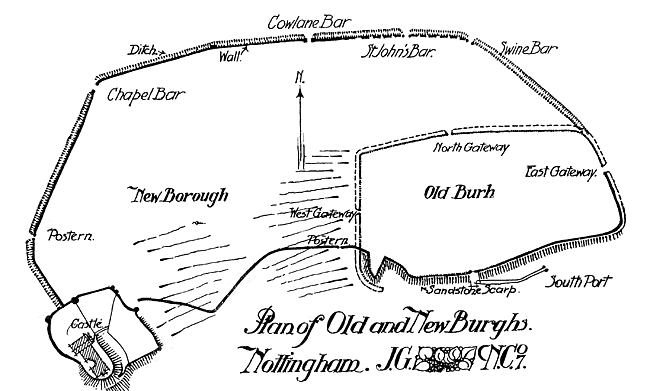
Some slight description is necessary of the sites of the Danish burh, and the extension westward of the New burh. The Old Burh, situated on St. Mary's Hill, would seem to have been bounded on the south by the sandstone scarp which rises abruptly from Narrow Marsh; and on the east the ditch was situated between Drury Hill and Bridlesmith Gate, and Middle Hill and Fletcher Gate. On the north it lay between Victoria Street, Carlton Street. Goose Gate, and Hockley on the one hand, and Bottle Lane, Warser Gate, and Woolpack Lane on the other. On the west, Count Street, Carter Gate, Sneinton Street, and Water Street bound the site of the ditch on the east and west sides respectively.
The extension of the town to the west and north now claims attention. Starting from Garner's Hill, which forms the south-west corner of the Old Burgh, the wall seems to have run down the west side thereof, and up the east side of Middle Hill; thence it ran westward to the Castle, and was composed for the most part of Bulwell Hill sandstone. From the north-west side of the Castle it seems to have run in a northerly direction along the east side of Park Row and on to Chapel Bar; and we find a postern to have existed somewhere about the end of the Rope Walk. From Chapel Bar the wall proceeded along the south side of Upper Parliament Street, and the edge of the pavement is on the outer face of the old wall.
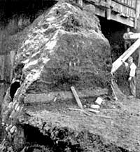
Front of old town wall in Lower Parliament Street.
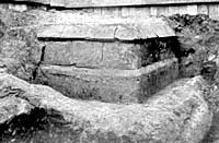
North-east corner of a buttress in the old town wall, opposite South Sherwood Street.
On reaching Market Street, the wall appears to have taken a course along the centre of Upper Parliament Street. When the Great Central Railway was constructed through Parliament Street, a section of the old wall and ditch was cut through. This portion of the wall was constructed of the Bunter sandstone upon which the town stands, but the plinths were of Lower Keuper sandstone, and the blocks varied in size from about 9 ins. to 13 ins. thick, and 17 ins. to 20 ins. long. The thickness of the wall seems to have been 7 ft. at the base; but this may quite possibly have varied to some extent.
The ditch at this point was 35 ft. wide on the east side of the railway cutting, and 30 ft. on the west, 20 ft. being its greatest depth, and it was cut out of the solid sandstone. It was mostly filled with black silt, containing fragments of pottery, bones, and occasional oyster-shells. This is the most easterly point at which traces of the wall have been recorded; but from references in the Borough Records to the Swine Bar, which was situated at the foot of Heathcote Street, it seems certain that the wall was continued to that spot.
From Swine Bar it seems probable that a ditch was the only defensive work to the east; and it would seem to have crossed Coalpit Lane, and curved round until it took up the line of the older ditch which encircled the Old Burh, cutting into it, apparently, at the junction of Hockley with Sneinton Street.
1 Borough Records, vol. i, p. 276.
2 Ibid., p. 278.
3 Borough Records, vol. ii, p. 61.
4 Ibid., p. 357.